- Flooding and rock slides close heavily damaged I-40 section in Smoky Mountains
- Erick upgraded to an 'extremely dangerous' Category 4 hurricane, US forecasters say
- Erick strengthens into a Category 3 major hurricane approaching Mexico's coast
- Erick upgraded to an ‘extremely dangerous’ Category 4 hurricane, US forecasters say
- Hurricane Season Week 3: Active Pacific keeps Atlantic quiet
Hurricane Laura: The latest on storm’s impact on Houston
-
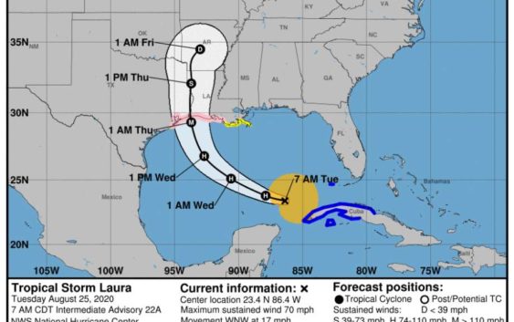
The latest track forecast for Tropical Storm Laura as of Tuesday, Aug. 25, 2020.
The latest track forecast for Tropical Storm Laura as of Tuesday, Aug. 25, 2020.
Photo: National Hurricane Center
The latest track forecast for Tropical Storm Laura as of Tuesday, Aug. 25, 2020.
The latest track forecast for Tropical Storm Laura as of Tuesday, Aug. 25, 2020.
Photo: National Hurricane Center
Good morning, Houston. Here’s the latest on Hurricane Laura:
Hurricane Laura is expected to make landfall on the Gulf Coast as a major hurricane Wednesday night.
7:30 a.m. update:
The National Hurricane Center upgraded Laura to a hurricane Tuesday morning, with maximum sustained winds of 75 mph.
Where the storm lands is yet to be seen, but the latest forecast from the National Hurricane Center shows a westward shift in the storm’s track that includes more of the Texas coastline. Laura is currently in the Gulf of Mexico and should rapidly intensify in the next 36 hours.
Meteorologists said that Laura’s track could still shift even more westward, but they stressed that early forecast (between two to three days out) have an 80-mile margin of error.
Hurricane Hunters will fly into the storm later today to obtain more specific data on the storm’s intensity.
Early Tuesday morning, the city of Galveston ordered a mandatory evacuation ahead of the storm.
jay.jordan@chron.com