- Road closures reported due to flooding in Myrtle Beach
- Town of Wrightsville Beach preparing for coastal flooding this weekend
- Man charged with sparking the most destructive wildfire in Los Angeles history
- Carolina Hurricanes start 2025-26 season hosting New Jersey Devils
- Speedy Sparks, bassist for Texas Tornados, other San Antonio music icons, has died
Chance for strong winds, tornadoes Saturday afternoon
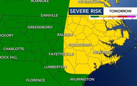
Starting at noon, eastern North Carolina is under a Level 2 risk for severe weather and the rest of the state is under a Level 1 risk for severe weather.
We could see heavy rain, 40 to 50 mph wind gusts and isolated tornadoes Saturday afternoon. The severe weather risk is in place because of a cold front that is rolling in, which Hurricane Laura’s remnants are bringing us.
The severe weather risk begins at noon and ends at 5 p.m.
As this system has moved across the country has produced a lot of severe weather — including tornadoes and warnings.
From the I-95 corridor and eastward we have the greatest threat of severe weather, WRAL meteorologist Elizabeth Gardner said.

By 1 or 2 p.m. we will start to see the storms develop. Our temperatures right now in the Triangle are really warm — in the upper 80s. But Sunday afternoon we are going to see much cooler weather.
WRAL meteorologist Kat Campbell said to move your weekend plans to Sunday. Tomorrow looks beautiful, with calmer and cooler weather. The heat and humidity will also begin to be much lower on Saturday heading into Sunday.

Sunday is shaping up to be a nice day with dry conditions and the lower humidity.
“Sunday looks great,” Campbell said. “So if you need to plan something outside, Sunday should be a sunny day and less humid, as well. So opt for Sunday for your weekend plans.”
