- Texas passed laws to address historic flooding. We asked a flood expert if they'll work.
- A city in Brunswick County is still repairing after Hurricane Florence
- Stein calls For $13.5 billion In new funding from Congress for Hurricane Helene Recovery
- Governor Stein expected to ask for federal release of Hurricane Helene relief funds in NC on Monday
- UNCW students honor Hurricane Florence anniversary at diaper bank
Severe weather threat diminishes, shifts to eastern counties
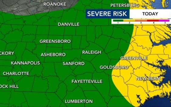
The severe threat forecast for North Carolina seems to be diminishing and shifting into eastern counties. The latest update now shows most of the Triangle area out of the level 2 threat for severe storms.
Due to the rain that moved through on Saturday morning, the remnants of Laura and severe weather seems to be receding. However, meteorologists warn the Triangle may not be out of the woods yet and should keep an eye out in case severe weather fires up again.
Temperatures around the Triangle and north have cooled down, reaching the high 70s and low 80s while the temperatures in eastern counties are still warmer, in the mid-upper 80s. That temperature contrast is why the threat for storms is still possible in our eastern counties.
Once the rain area near Downtown clears, Raleigh should be dry the rest of the day, according to WRAL meteorologist Zach Maloch.
The threat should be diminished everywhere by 6 or 7 p.m.

But Sunday afternoon should be even cooler – a beautiful day for spending time outdoors.
WRAL meteorologist Kat Campbell said to move your weekend plans to Sunday. The heat and humidity will also begin to be much lower on Saturday heading into Sunday.

Sunday is shaping up to be a nice day with dry conditions and the lower humidity.
“Sunday looks great,” Campbell said. “So if you need to plan something outside, Sunday should be a sunny day and less humid, as well. So opt for Sunday for your weekend plans.”
