- Why no hurricanes made landfall in the US in 2025
- Florence to begin interviewing police chief finalists in January
- A West Texas county wants to better prepare for floods. Paying for it will be tricky.
- They couldn’t save their daughters’ lives in the July 4 floods. Now they’re dealing with the grief and the guilt.
- Austin could see heavy rains, possible flooding over the next few days
National Hurricane Center monitoring three tropical systems in the Atlantic storm basin
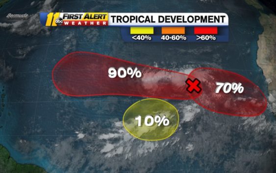
RALEIGH (WTVD) — The National Hurricane Center is monitoring three tropical waves in the Atlantic storm basin, one of which is very likely to form into at least a tropical depression.
The most concerning tropical wave is located over the eastern Atlantic Ocean. It is currently just an unorganized group of showers and thunderstorms, but by next week it could be more.
The system is moving west-northwest into the central Atlantic Ocean. There it will run into conditions that are more favorable for it to strengthen and organize into a stronger system.
There is a 50 percent chance the storm becomes a tropical depression in two days. There’s a 90 percent chance the storm becomes a tropical depression in the next five days.
Storm Ready 2020: Preparing in a Pandemic
The other system in the Atlantic has just a 10 percent chance to develop in the next five days
The third system is still located over Africa. Long-range forecasts do give this system a descent chance of forming, but it’s not until the middle or end of next week.
Having this many systems developing at once is not unusual for this time of year. The middle of September is the peak of hurricane season.
Yet, this hurricane season has been more active than usual. It is on pace to have the most named storms ever, breaking the record set in 2005. The following tropical storms all set records as the earliest of their respective first letters to ever form: Cristobal, Edouard, Fay, Gonzalo, Hanna, Isaias, Josephine, Kyle, Laura, Marco, Nana, and Omar.
Copyright © 2020 WTVD-TV. All Rights Reserved.