- New children’s book highlights deputies’ role in Hurricane Helene recovery
- Travis County is raising property taxes to pay for past and future floods
- Many ask where the hurricanes are this season as the Atlantic remains quiet
- Texas passed laws to address historic flooding. We asked a flood expert if they'll work.
- A city in Brunswick County is still repairing after Hurricane Florence
Zeta reverts back to tropical storm as it moves over Yucatán Peninsula, expected to strengthen back into hurricane
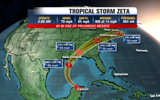
RALEIGH, N.C. — Zeta weakened back into a tropical storm overnight as it moved over the Yucatán Peninsula.
According to the National Hurricane Center, Zeta has maximum sustained winds of 70 miles per hour, and it is moving northwest at 14 miles per hour. As of 5 a.m., it’s 85 miles east-southeast of Progreso, Mexico.
Working over land has weakened Zeta, but it is expected to strengthen back to Hurricane level as it heads toward open water.
Parts of the peninsula are under a hurricane warning. It will then head into the Gulf of Mexico and start tracking toward Louisiana, where it is expected to make landfall sometime Wednesday afternoon.
Louisiana has felt the brunt of the record-setting 2020 hurricane season. So far, four named storms–Cristobal, Delta, Laura, and Marco–have made landfall in the state.
Louisiana Gov. John Bel Edwards urged his state’s citizens to monitor the storm, and the state activated its Crisis Action Team.
Storm Ready 2020: Preparing in a Pandemic
Zeta broke the record for the earliest storm of its name, which was set on Nov. 29, 2005.
This year’s season has so many storms that the hurricane center has turned to the Greek alphabet after running out of official names. Zeta is the furthest into the Greek alphabet the Atlantic season has gone.
Copyright © 2020 WTVD-TV. All Rights Reserved.