- Carolina Hurricanes start 2025-26 season hosting New Jersey Devils
- Speedy Sparks, bassist for Texas Tornados, other San Antonio music icons, has died
- Authorities make an arrest related to deadly January wildfire that leveled LA neighborhood
- AI simulation gives Carolina Hurricanes 20% chance to win 2026 Stanley Cup
- Warf steps down as president of Carolina Hurricanes
Much of central NC at risk for flooding, heavy rain on Wednesday
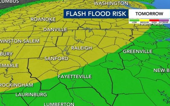
Raleigh, N.C. — Much of central North Carolina, from Greenville and the Interstate 95 corridor west through the Triangle and the Triad, is at a medium risk for flash flooding through Wednesday.
A cold front crossing from west to east will push showers across the state beginning as early as Tuesday afternoon.
There is a slight chance for showers Tuesday afternoon into the evening. WRAL meteorologist Elizabeth Gardner said the day will be partly cloudy and very warm, with a high around 79 degrees, close to the record of 81 degrees.
Look for rain to build in through Wednesday.
Track rain with the DualDoppler5000
“We expect cloudy conditions with scattered to widespread showers and perhaps some storms as tropical moisture moves in from the Atlantic mixing with a cold front arriving from the Midwest,” Gardner said.
“Some of the rain could be heavy at times, especially in the afternoon and into the night.”

Thursday will be another rainy day, and through Friday, we could see up to 5 inches of rain.
Temperatures stay warm, though, with highs in the 70s and overnight lows in the 60s.
Friday brings fewer showers and the start of a few cooler days. The weekend also looks mild, with highs in the mid to upper 60s, although the rain chance lingers through Saturday.
