- Speedy Sparks, bassist for Texas Tornados, other San Antonio music icons, has died
- Authorities make an arrest related to deadly January wildfire that leveled LA neighborhood
- AI simulation gives Carolina Hurricanes 20% chance to win 2026 Stanley Cup
- Warf steps down as president of Carolina Hurricanes
- Tornado in North Dakota was the first at EF5 strength in a dozen years
NC weather: Morning ice and rain again activate alerts for winter storm warning, flash flood watch
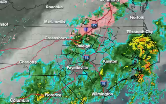
RALEIGH, N.C. (WTVD) — Friday morning is looking much like Thursday morning with rain and freezing rain falling across all of central North Carolina.
Temperatures are right around freezing again this morning and the area is sill under a few different weather advisories.
A Winter Storm Warning is in effect until 7 a.m. for Granville, Person, Vance and Warren counties.
A Winter Weather Advisory is in effect until 7 a.m. for Alamance, Chatham, Durham, Franklin, Halifax, and Orange counties.
Plus, the southern half of the ABC11 viewing area is under a Flash Flood Warning until 7 a.m. This specifically impacts Cumberland, Edgecombe, Harnett, Hoke, Johnston, Sampson, Scotland, Wayne, and Wilson counties.
Live radar | First Alert Weather
Rain and freezing rain will continue to fall through the morning. Rain should start tapering off by late morning and hopefully be out of the area by noon or early afternoon.
Clouds will blanket the sky through the evening. When the clouds break Friday night, extremely cold air will move into the area. Lows will be in the 20s.
How to contact your power company
The weekend is shaping up to be clear and sunny–but cold.
Highs will be in the low to mid 40s for Saturday and Sunday, and overnight lows will fall into the 20s.
However, by mid-week, we should see temperatures rise into the 60s.
WATCH: Why do we get freezing rain instead of snow or sleet?
Copyright © 2021 WTVD-TV. All Rights Reserved.