- Authorities make an arrest related to deadly January wildfire that leveled LA neighborhood
- AI simulation gives Carolina Hurricanes 20% chance to win 2026 Stanley Cup
- Warf steps down as president of Carolina Hurricanes
- Tornado in North Dakota was the first at EF5 strength in a dozen years
- Eric Tulsky comfortable, confident and going for the Stanley Cup in 2nd year as Hurricanes GM
WEATHER TIMELINE: 'Moderate' tornado chance, 'high' wind damage possible in North Carolina on Thursday
RALEIGH, N.C. (WTVD) — It has been a warmer and relatively clear Wednesday but that will give way to a potentially dangerous Thursday.
To get the latest weather alerts sent straight to your phone, download the ABC11 app
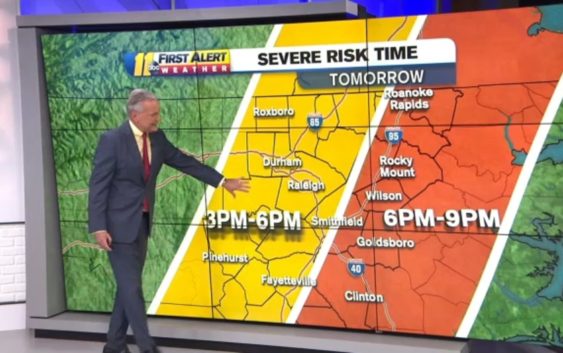
Severe weather that moved through the Deep South on Wednesday is expected to arrive in central North Carolina on Thursday afternoon with the danger zones between 3 p.m. and 9 p.m.
New weather models issued early Wednesday caused the National Weather Service to increase our risk for severe weather from enhanced to moderate. This is a rare risk level.
Timeline
Chief Meteorologist Chris Hohmann said starting about 3 p.m. Thursday, areas from Alamance County east, including Durham, Wake and Person counties as well as down to the Moore County and Cumberland County areas will be in the severe risk time.
After 6 p.m., the severe risk will shift to areas further east, including Rocky Mount, Wilson and Goldsboro.
The last time central North Carolina was in a moderate severe-weather risk the day before storms arrived was late December 2012. Although, truth be told, that severe risk fizzled. The storms that arrived did not cause any reports of serious damage.
The latest update from @NWSSPC puts almost our entire viewing area under a Cat 4 (moderate) of 5 risk for severe storms on Thursday. Biggest threat=damaging winds. Almost 11 million people in this area. #ncwx pic.twitter.com/aFZplWTulm
— 𝘿𝙤𝙣 𝙎𝙘𝙝𝙬𝙚𝙣𝙣𝙚𝙠𝙚𝙧 (@BigweatherABC11) March 17, 2021
The damaging wind probability is at the highest risk level possible. There is a nearly 45 percent chance that damaging straight-line wind will happen somewhere in central North Carolina. That means wind gust anywhere from 70-90 miles per hour.
The tornado threat is less likely but still possible. The threat level is moderate, which translates to a 15 percent chance that an EF2-EF5 tornado could happen.
Localized flooding and hail are also possible with the system.
WATCH: Big Weather breaks down most likely scenarios for Thursday’s storm
One thing to keep an eye out for happens Thursday morning. That’s when we could see some scattered showers ahead of the arrival of the severe storms.
The presence of Thursday morning showers would be a good sign, according to ABC11 Meteorologist Don “Big Weather” Schwenneker. He said showers in the morning would help stabilize the atmosphere, which in turn could reduce the severity of the storms when they arrive later in the day.
Once this weather event is over, rain could linger around into Friday. Temperatures during the day fall into the 40s with gusty wind.
Saturday and Sunday will see temperatures in the 50s, with more sun Saturday and more warmth Sunday.
If you’re a fan of the warmer spring weather, 70s will return next week.
GMA’s Ginger Zee joins the First Alert Team for Severe Weather townhall
SCHOOL CLOSINGS DUE TO WEATHER
Durham, Orange, Johnston, Granville, Cumberland, Person and Wayne counties will all be in remote instruction Thursday due to the impending weather.
On Thursday, Moore County Schools will release students three hours early and all after-school activities will be canceled.
Copyright © 2021 WTVD-TV. All Rights Reserved.