- Families of campers, counselors who died in Texas Hill County floods sue Camp Mystic
- Small plane bound for Jamaica with hurricane relief supplies crashes in Florida neighborhood
- Ask the Meteorologist: Did a tornado hit Johnston County Saturday night?
- Demolition begins on flood-damaged homes in Stoney Creek as neighbors await relief
- NC Office of State Fire Marshal aiding in Hurricane Melissa relief efforts
Central North Carolina under Level 2 for severe weather; strong storms with damaging winds possible
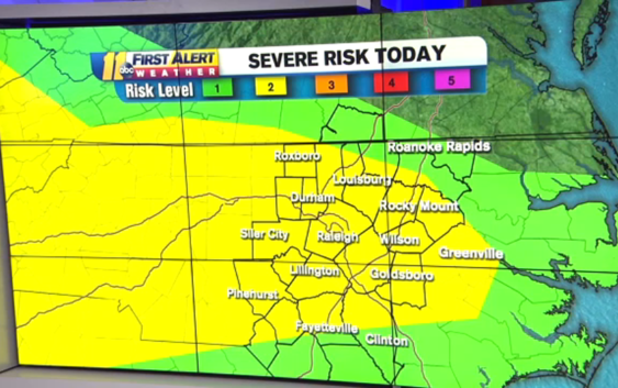
On Saturday, central North Carolina is under a Level 2 out of 5 risk for severe weather, meaning some areas may see damaging winds and large hail.
First Alert Meteorologist Robert Johnson said a frontal boundary will move through the Carolinas Saturday afternoon, producing spotty showers and isolated thunderstorms.
Severe Thunderstorm Warning in effect for part of Moore and Chatham county until 5pm. Main threat is damaging winds. Small hail also possible. pic.twitter.com/icTOZlHHEI
— Robert Johnson (@RobJohnsonABC11) March 27, 2021
A Tornado Warning is in effect for Wake, Johnston, Nash and Wilson Counties until 6 p.m
A Severe Thunderstorm Warning is in effect for Lee and Moore counties until 5:45 p.m. A Severe Thunderstorm Warning is also in effect for Wake, Durham, Franklin, Chatham and Granville counties until 5:30 p.m.
A Tornado Warning was in effect for Lee and Moore counties until 5 p.m.
The entirety of North Carolina is under a Severe Thunderstorm Warning until 8 p.m. The main threat for these regions are damaging winds and large hail. After 8 p.m., Meteorologist Robert Johnson said to expect a warm and cloudy night with patchy fog developing — but not as heavy as this morning.
What are straight-line winds and how do they form
As a potent low-pressure system passes through the Northeast Sunday, a cold front tied to the system will sweep across the Southeast and Mid-Atlantic Sunday night into Monday. This is expected to bring another round of rain and gusty thunderstorms. Around the Triangle, damaging winds will be a possible threat.
Copyright © 2021 WTVD-TV. All Rights Reserved.