- North Carolina’s leaders give insight on the effects of Hurricane Melissa
- ‘We want some answers;’ Whiteville residents demand city response to prevent flooding
- Halifax County couple OK after riding out Hurricane Melissa in Jamaica
- Hurricane Melissa leaves 25 dead in Haiti, causes widespread damage in Jamaica and Cuba
- Category 5 Hurricane Melissa brings flooding and catastrophic winds to Jamaica
Forecast: Light rain linger tonight; more severe weather possible Friday
AUSTIN, Texas — Another busy weather day across Central Texas with severe storms sweeping through our northern counties. There were many reports of hail as large as baseballs in parts of Mason and Burnet counties. Golf ball size hail was reported in Williamson County.
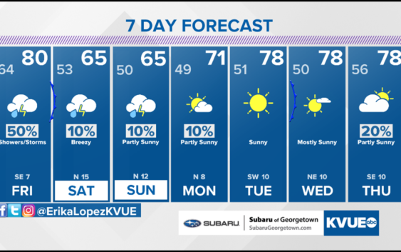
We aren’t completely done with the severe weather threat this week. Friday brings a 50% chance of scattered showers and storms with a “Marginal Risk” for severe weather which is a level 1 out of 5 threat. Large hail and damaging winds will be our primary concern once again.
A cold front will push through Central Texas late Friday. This front will bring a thin line of showers and storms through Central Texas Friday night, but big changes will settle in behind this front for the weekend.
Temperatures turn much cooler with highs only in the 60s both Saturday and Sunday. Rain chances also trend much lower with just 10% chance of spotty rain.
THURSDAY NIGHT:
Cloudy with a 40% chance of showers and storms. East wind at 10 mph.
LOW: 64°
FRIDAY:
Cloudy with a 70% chance of showers and storms. South wind at 5 to 10 mph.
HIGH: 82°
SATURDAY:
Mostly cloudy. 50% chance of showers and storms. East/northeast wind at 10 mph.
HIGH: 66°