- Authorities make an arrest related to deadly January wildfire that leveled LA neighborhood
- AI simulation gives Carolina Hurricanes 20% chance to win 2026 Stanley Cup
- Warf steps down as president of Carolina Hurricanes
- Tornado in North Dakota was the first at EF5 strength in a dozen years
- Eric Tulsky comfortable, confident and going for the Stanley Cup in 2nd year as Hurricanes GM
Forecast: More severe weather ahead for Friday, upper 70s
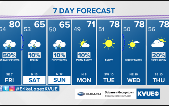
AUSTIN, Texas — Spring is here, and despite the beautiful blooms and green, storms are continuing to rear their ugly heads in the area. We aren’t completely done with the severe weather threat this week. Friday brings a 70% chance of scattered showers and storms with a “Marginal Risk” for severe weather which is a level 1 out of 5 threat.
We are tracking a cold front poised to cross Central and South-Central Texas between 5p-9p this evening. Ahead of the front, we will continue to have a soupy air mass during the day with the possibility of some passing showers this morning. A warm front will premiere during the day and that will dictate how warm our temperatures will climb during the day in addition to the cloud cover. As the front passes thanks to a northerly trough, we can expect some gusty winds, moderate to heavy rain, and medium-to-large hail again. These are the major threats.
Temperatures turn much cooler with highs only in the 60s both Saturday and Sunday. Rain chances also trend much lower with just 10% chance of spotty rain.
FRIDAY:
Cloudy with a 70% chance of showers and storms. East-southeast wind at 5 to 10 mph.
HIGH: 79°
FRIDAY NIGHT:
Partly cloudy with a 20% chance of showers and storms. East wind at 10 mph.
LOW: 64°
SATURDAY:
Partly cloudy with peeks of sun yet mainly dry. East-northeast wind at 10 mph.
HIGH: 65°