- Speedy Sparks, bassist for Texas Tornados, other San Antonio music icons, has died
- Authorities make an arrest related to deadly January wildfire that leveled LA neighborhood
- AI simulation gives Carolina Hurricanes 20% chance to win 2026 Stanley Cup
- Warf steps down as president of Carolina Hurricanes
- Tornado in North Dakota was the first at EF5 strength in a dozen years
Flash Flood Watch for multiple counties until 9 p.m. Monday as more rain moves in
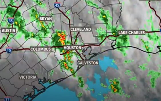
The ground is very saturated, so it won’t take much for ponding to form on our roadways.
HOUSTON — Keep the umbrella handy again today. Starting the day wet and end the day wet. There’s a 70 percent change of rain throughout the day, with temperatures staying in the 70s.
Flash Flood Watch
A Flash Flood Watch is in effect until 9 p.m. Austin, Coastal Brazoria, Fort Bend, Grimes, Inland Brazoria, Inland Harris, Montgomery, Waller and Washington counties.
“A band of storms this morning from around Freeport feeding up into Fort Bend and Harris counties will continue to do so through early afternoon. Training of storms will be piling up the rainfall in these areas and rainfall totals of 2 to 3 inches will be common with isolated totals in excess of 6 inches. The flood threat will be strongly dependent on the location of the heaviest precipitation axis. If any heavy rain falls on already saturated grounds, flash flooding can be expected.”
Tuesday, the rain chances stay high at 60 percent. By Wednesday, rain chances drop down to about 30 percent, then high pressure moves in to keep the rain chances down and the temperatures start to rise leading into the Memorial Day weekend.
Right now, long range models have us being spared any shower activity for Memorial Day itself. Stay tuned!