- 911 calls from Texas floods reveal chaotic and desperate pleas for rescues
- Carolina Beach is warning of potential King Tide flooding
- NCDEQ launches Hurricane Helene recovery grants program
- Why no hurricanes made landfall in the US in 2025
- Florence to begin interviewing police chief finalists in January
Southeast counties near San Antonio under flash flood watch through Friday
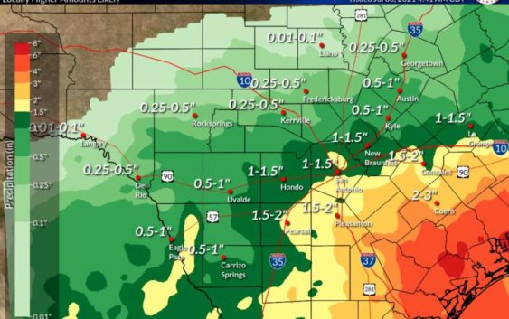
Three area counties are expected to get quite a bit of rain

While San Antonio is not expected to get the worst of Thursday’s rain, residents should still be prepared for another round of wet conditions.
National Weather Service
More rain could be in our future, San Antonio.
The National Weather Service says counties surrounding the Alamo City will see isolated to scattered showers and storms on Thursday, according to the latest forecast.
Areas south of the corridor at I-10 and U.S. 90 are likely to have more wet conditions through Friday. The agency predicts that between 1 to 2 inches of rainfall are possible for the I-10 corridor from San Antonio to La Grange, though this may change as showers and storms occur.
READ MORE: Nationally lauded San Antonio brunch spot Comfort Café closed due to flooding
There is a flash flood watch for Lavaca, DeWitt, and Karnes counties through Friday evening. These counties are expected to get between 1 to 4 inches of rain, though some areas may see 5 to 7 inches.
Even though the flash flood watch is for Lavaca, DeWitt, and Karnes counties, NWS is advising residents in San Antonio, New Braunfels, and La Grange to be aware of weather conditions since heavier rains could develop.
Read more from Sarah