- U.S.-based aid groups rush to get supplies into storm-battered Jamaica after Hurricane Melissa
- Travelers stuck in Jamaica due to Hurricane Mellissa forced to pay for unwanted extended stay
- Raleigh police officer awaits word from family in Jamaica after Hurricane Melissa devastation
- North Carolina’s leaders give insight on the effects of Hurricane Melissa
- ‘We want some answers;’ Whiteville residents demand city response to prevent flooding
Grace strengthens into a hurricane: Track the storm, spaghetti models, possible landfall

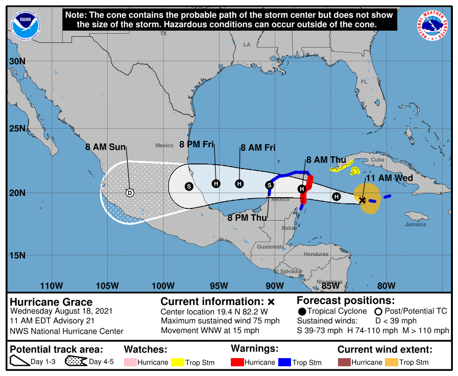
Grace has strengthened into a hurricane, and continues to strengthen in the Caribbean Wednesday.
Hurricane Grace has maximum sustained winds of 75 mph, according to the 10 a.m. advisory from the National Hurricane Center.
Grace is forecast to continue strengthening, and is expected to reach the eastern Yucatan Peninsula early Thursday morning, and enter the western Gulf of Mexico Friday. Weakening is expected as it passes over the Yucatan Peninsula, but some restrengthening is expected as it moves into the Gulf.
Hurricane-force winds extend outward up to 25 miles from the
center and tropical-storm-force winds extend outward up to 115 miles.
The storm is located 65 miles southwest of Grand Cayman, and is moving west-northwest at 15 mph. It is expected to continue a westward to west-northwestward movement for the next several days.
Cone of uncertainty: See the latest graphic from the NHC
Satellite images: See latest satellite image from NOAA, for a clearer picture of the storm’s size
Later Wednesday morning, Grace is expected to pass over the Cayman Islands, and the current track has the storm moving into Mexico early Saturday morning.
Latest data on Hurricane Grace
Here is the latest data on Hurricane Grace pulled from the National Hurricane Center’s latest advisory.
- Location: 65 miles west of Grand Cayman
- Maximum sustained winds: 75 mph
- Movement: West-northwest at 15 mph
- Pressure: 992 MB (millibars)
- When next advisory will be released: 1 p.m. CT