- U.S.-based aid groups rush to get supplies into storm-battered Jamaica after Hurricane Melissa
- Travelers stuck in Jamaica due to Hurricane Mellissa forced to pay for unwanted extended stay
- Raleigh police officer awaits word from family in Jamaica after Hurricane Melissa devastation
- North Carolina’s leaders give insight on the effects of Hurricane Melissa
- ‘We want some answers;’ Whiteville residents demand city response to prevent flooding
NC weather: Winds, hail, tornado possible with elevated severe storm risk today
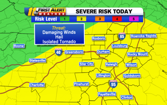
RALEIGH, N.C. (WTVD) — Severe weather is possible in central North Carolina on Wednesday.
The weather system that brought tornadoes to Texas and Louisiana is pushing into North Carolina.
The National Weather Service has placed the region under a level 2 of 5 risk for severe storms. The storms could include damaging winds, hail and even isolated tornadoes.
TIMING
Scattered showers could begin around noon. However, the strongest storms will not arrive until a little bit later.
You can expect the worst weather to happen between 2-10 p.m.
Any slow moving storms could cause flooding in low-lying areas.
While the bulk of the storms will move out Wednesday night, some could linger into Thursday. By Thursday afternoon, all of the storms should have moved out of the area and toward the coast.
Temperature-wise, Wednesday and Thursday will see highs in the upper 60s and low 70s for most of the area.
Copyright © 2022 WTVD-TV. All Rights Reserved.