- Warf steps down as president of Carolina Hurricanes
- Tornado in North Dakota was the first at EF5 strength in a dozen years
- Eric Tulsky comfortable, confident and going for the Stanley Cup in 2nd year as Hurricanes GM
- 5 homes collapse into the surf of the Outer Banks as hurricanes rumble in Atlantic
- As hurricanes pass offshore, more Buxton homes collapse into the sea
First look at the 2022 Atlantic hurricane season
June 1, the start of the 2022 Atlantic hurricane season is 55 days away and we are already getting the first extended range forecast for the season to come.
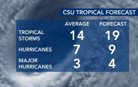
Colorado State University releases one such forecast that helps breakdown what to expect. After seeing six straight hurricane seasons with above-normal activity (2016 – 2021) you would think we’d get a break, but that does not look to be the case. CSU is forecasting another above-normal season with 19 total names storms: 9 becoming hurricanes and 4 becoming major hurricanes.
The answer to why we will see another above-normal hurricane season lies within both the current phase of the El Niño–Southern Oscillation (ENSO) and near-to/above-normal sea surface temperatures in the tropics.
What is the El Niño–Southern Oscillation (ENSO) in a nutshell?
The earth’s climate undergoes cyclical changes regularly like seasonal patterns that occur annually. There are less-regular cycles with durations from a few months up to several decades and, while their cause is not clearly understood, their changes in one part of the world can have well defined effects on global weather patterns. The cycles are generally defined by changes in air pressure, sea temperature and wind direction over oceans.
The El-Niño-Southern Oscillation (ENSO) is one such cycle that has three phases defined by sea surface temperatures in the equatorial Pacific Ocean. We have the warm phase, El Niño, the cold phase, La Niña and the neutral phase, ENSO Neutral. Currently, La Niña conditions are present creating weaker westerly trade winds which reduces the amount of vertical wind shear in the atmosphere. Tropical systems thrive in environments with low vertical wind shear.

Beyond the current phase of the El Niño–Southern Oscillation, sea-surface temperatures in the Atlantic and Caribbean are extremely important for tropical development. Currently, water temperatures in the eastern Atlantic are cooler-than-normal, but that is typical for this time of year and tropical development isn’t likely in that location until late-August and September.
In May and June, tropical development is often closer to the United States and that is where temperatures are currently above normal. This is something we will watch over the next 55 days.


Typically, even though the last few hurricane seasons have seen a lot of activity early on, tropical activity is rather low in June and July while the highest activity is in August, September, and October.

As we head towards the start of the Atlantic hurricane season WRAL’s team of meteorologists will continue to monitor these atmospheric conditions conducive for tropical development.
You can download the WRAL Weather App and click on “Hurricane Center” to monitor the tropics throughout the season.
Of course, we’ll provide updates on every system that develops this season on WRAL News.
