- Carolina Beach is warning of potential King Tide flooding
- NCDEQ launches Hurricane Helene recovery grants program
- Why no hurricanes made landfall in the US in 2025
- Florence to begin interviewing police chief finalists in January
- A West Texas county wants to better prepare for floods. Paying for it will be tricky.
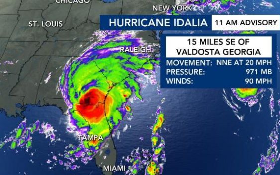
Live updates: Rain from Hurricane Idalia begins falling in southern NC counties; Triangle to see impacts by evening commute
TAMPA, FLA. —
What to know now about Hurricane Idalia
- Hurricane Idalia made landfall in Florida around 8 a.m. on Wednesday.
- Idalia is expected to be a tropical storm by the time it reaches North Carolina. The greatest threat is for flooding, especially in the south and east of the Tar Heel State.
- Coastal NC counties are under alert. Tropical Storm Warnings are in effect for our coastline and multiple non-coastal counties. A Tornado Watch has been issued for Brunswick, New Hanover, Pender and Columbus counties.
- Flash Flood Warnings are also in place for much of the viewing area, including the Triangle.
- Some schools, colleges and businesses are issuing closings or delays.
Timeline of Idalia’s impact on North Carolina
2:30 p.m.: Wilson, Moore and Nash County schools are closed Thursday due to Hurricane Idalia’s potential impact on NC.
2:20 p.m.: Cumberland County schools switch to remote learning for Thursday. Cumberland County is under a Tropical Storm Warning. Edgecombe County schools are closed Thursday due to Hurricane Idalia’s potential impact on NC.
2 p.m.: Rain from Hurricane Idalia begins impacting North Carolina’s southern counties and part of the coast.
Noon: A Tornado Watch was issued for several coastal counties, including New Hanover, Pender and Brunswick.
11:45 a.m.: Cumberland County has been included in the Tropical Storm Warning.
Timing: Arrival of impacts from Idalia in NC
Light rain will begin around 1 to 3 p.m. in our southern counties, with heavier rain bands moving through the Triangle around 3 to 5 p.m. The evening commute will likely be very rainy and messy.
Rain overnight will get heavier around 4 a.m. Thursday, especially in counties southeast of the Triangle. However, by noon Thursday the rain will begin fizzling out, and by 5 p.m. Thursday it should be completely gone.

The Triangle could get 1 to 2 inches of rain. Fayetteville, Goldsboro and Wilson could see over 5 inches of rain, with the biggest impact being between 3 or 5 a.m. on Thursday.
Wind speeds up to 35 mph are possible in the Triangle, and speeds of up to 45 mph are in eastern counties, where power outages are more likely.
Rain totals will be very varied during this hurricane, but the biggest concern is flooding southeast of the Triangle.

Most of the NC coast could see a storm surge of 1 to 3 feet, but along the southern NC coast, storm surge and flooding will be higher.
NC is a ‘Storm Magnet:’ Podcast with WRAL Meteorologist Kat Campbell
Florida residents hunker down ahead of Idalia
“You still have time this morning to make your final preparations … but you gotta do that now.” Gov. Ron DeSantis announced at the state’s emergency operations center. Tolls have been waived on highways out of the danger area, shelters have opened, hotels are prepared to take evacuees and more than 30,000 utility workers are being staged to make repairs as quickly as possible in the hurricane’s wake, he said.“You do not have to leave the state. You don’t have to drive hundreds of miles. You have to get to higher ground in a safe structure. You can ride the storm out there, then go back to your home,” DeSantis said.
“Right now, the biggest hazards are storm surge,” Robbie Berg, a senior hurricane specialist at the National Hurricane Center in Miami, said Tuesday morning. “We’re expecting a surge as much as 8 to 12 feet above normal tide levels in portions of the Big Bend area of Florida.”
Idalia thrashed Cuba with heavy rain, especially in the westernmost part of the island, where the tobacco-producing province of Pinar del Rio is still recovering from the devastation caused by Hurricane Ian. Residents were evacuated to friends’ and relatives’ homes as up to 4 inches (10 centimeters) of rain fell, meteorological stations reported.
Idalia is the first storm to hit Florida this hurricane season, but only the latest in a summer of natural disasters, including wildfires in Hawaii, Canada and Greece; the first tropical storm to hit California in 84 years, and devastating flooding in Vermont.
Florida airports close; expect delays along east coast
Many school districts along the Gulf Coast said they would be closed Tuesday and Wednesday. Several colleges and universities said they would close their campuses on Tuesday, including the University of Florida in Gainesville.
“They told us that our dorm building, especially, is prone to flooding,” said Erin Amiss, a student at Eckerd College in St. Petersburg.
MacDill Air Force Base, located on Tampa Bay, is preparing to evacuate several aircraft and began a mandatory evacuation Monday morning for personnel who live in local counties, the Air Force said in a statement.
The National Oceanic and Atmospheric Administration recently said the 2023 hurricane season would be far busier than initially forecast, partly because of extremely warm ocean temperatures. The season runs through Nov. 30, with August and September typically the peak.
___
Associated Press contributed to this report.