- Springfield Middle School to receive new mobile classrooms following tornado damage
- Several Raleigh homes damaged by fire caused by lightning strike
- Three Raleigh homes damaged by fire caused by lightning strike
- Carolina Hurricanes forward Jesper Fast expected to miss season after neck surgery
- New AI system helps Central Texas first responders detect wildfires as they happen
A Tropical Storm in The Gulf Could Bring Flash Floods to San Antonio
As Hurricane Florence pounds the East Coast, another tropical storm headed for Texas will bring more rain and possible flash flooding to San Antonio.
A “weak low pressure” center that formed in the Gulf of Mexico southeast of Brownsville will bring heavy rains and gusty winds to parts of south Texas and northeastern Mexico after it reaches the coast on Friday, according to National Hurricane Center forecasts.
This could cause flash flooding in San Antonio as storms drop 1 to 3 inches of rain from Friday through Sunday, with up to 5 inches possible in some areas, according to the National Weather Service.
That rain is likely to cause flooding and road closures as the deluge lands on already soggy ground.
“Just from driving around, you can kind of tell that the ground is saturated,” National Weather Service warning coordination meteorologist Paul Yura said.
“A lot of the springs are flowing, the creeks are still flowing, there’s lots of water in places … you can kind of see that everything is still primed now for additional rains to get more runoff,” he continued.
In preparation for the floods, Bexar County Public Works staff already have placed barricades at some flood-prone roads and will be monitoring low-water crossings in unincorporated parts of the county, county officials said in a Thursday news release.
Crossing a barricade can lead to criminal charges with a maximum $2,000 fine and 180 days in jail, San Antonio Fire Department public information officer Woody Woodward said in an email.
“Even in relatively shallow water, tires can act as flotation devices lifting up even large vehicles and sending them downstream,” he said. “Your vehicle may stall out in just a few inches of water, and a foot or two of water is enough to float a 3,000-pound car.”
Forecasters are expecting the most severe flooding along the coast.
On Thursday, Texas Department of Transportation crews from Austin, Waco, Brownwood, San Angelo, and Bryan congregated at the San Antonio district office. They staged around 100 pieces of equipment, including skid steers, loaders, and heavy-duty trucks, to use in places like Corpus Christi and the Rio Grande Valley, if needed.
“They have their own resources,” said TxDOT public information officer Hernan Rozemberg. “But if this thing starts getting a little out of hand and they need more help, this is where the people are going to be dispatched to help them out.”
After two weeks of intermittent storms, San Antonio already has recorded its third-wettest September on record, Yura said. The previous wet weather this month was the result of warm, moist Gulf air colliding with cool air from West Texas.
While it has only a 20 percent chance of becoming a swirling cyclone over the next couple days, the storm will bring more atmospheric moisture on top of what’s already streaming in from the Gulf.
“That moisture we had last week really hasn’t even left,” Yura said. “So it’s that, and then we’re adding even more.”
Bonnie Arbittier / Rivard Report
Vehicles carrying emergency equipment in preparation of response to costal floods gather at the San Antonio TxDOT office staging area.
Bonnie Arbittier / Rivard Report
A TxDOT employee directs vehicles carrying emergency equipment in preparation of response to costal floods.
By Monday and Tuesday, forecasters expect a ridge of high pressure to slowly build back into Texas and dry out the atmosphere, he said. This ridge is similar to what caused drought conditions for most of the summer.
“It won’t be as intense,” Yura said. “Because the ground is so wet, it’s going to be quite warm and quite humid now for a while.”
Here are the Rivard Report’s picks for best online resources to get accurate, real-time information on flooding in San Antonio.
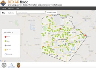
BexarFlood.org displays information from 178 sensors installed at low water crossings around Bexar County. These sensors indicate a road is closed due to flooding, open, or if drivers should use caution. This is the fastest way to find out what parts of the city are flooding in real time.
Hurricanes and Tropical Storms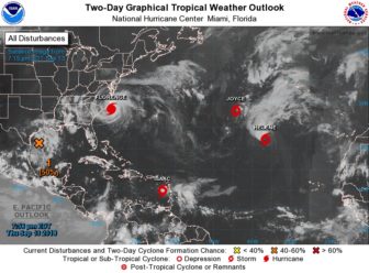
The National Oceanic and Atmospheric Administration frequently updates its National Hurricane Center website to give an overview of every tropical cyclone on the Atlantic and Pacific coasts.
River Flooding Forecasts
Many Texans know their way around a stream gauge because of their passion for floating rivers, but the best place to find forecasts for flooding in rivers and streams is the River Forecast Center. Select the Austin-San Antonio forecast office, and see how regional river levels will likely change over the next five days.
Changes in Edwards Aquifer Levels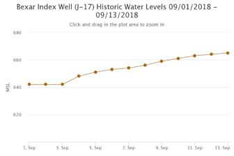
Plenty of sources show the daily levels of the J-17 well that taps the Edwards Aquifer below San Antonio, but the records go surprisingly far back. On this page of the Edwards Aquifer Authority’s website, users can look up daily aquifer levels back to Nov. 12, 1932, and make custom graphs.