- Severe weather leads to fallen trees, car crashes and flooding around the Triangle
- New video shows vehicles being swept away in historic, deadly flash floods in SA on June 12
- $40 million to go to underserved SC counties for Hurricane Helene recovery. Here's what you need to know.
- Family honors Air Force veteran Derwin Anderson Jr. after he died in June flash floods
- City of Wilmington addresses flooding on New Centre Drive
HURRICANE FLORENCE: Wilmington sees strongest wind gust since 1958
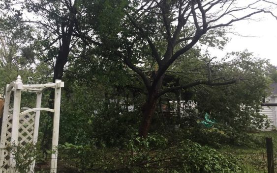
Extensive power outages, road closures across Southeastern North Carolina
SOUTHEASTERN N.C. — More than 125,000 customers were without power Friday as Hurricane Florence arrived in Wilmington with full force, bringing wind, storm surges and historic rain.
Florence’s eye made landfall over the Wrightsville Beach water tower, according to the National Weather Service (NWS) office in Wilmington. It hit the coast as a Category 1 storm with 90 mph maximum sustained winds, the NWS said.
The storm’s arrival brought a 105 mph wind gust at the NWS office about 7 a.m. Friday, said meteorologist Jordan Baker. He said the gust was the strongest recorded in Wilmington since 1958.
Coastal homes and buildings suffered damage from initial wind and storm surges. Through Friday, the storm stalled, dumping historic rains that weather officials said would ultimately be up to 30 to 40 inches in some places. That amount will cause catastrophic flooding throughout the Wilmington region and shatter rainfall records, according to the weather service.
“We call them disasters because they break things,” Brock Long, head of the Federal Emergency Management Agency (FEMA), told reporters while Florence was bearing down on the coastline. “The infrastructure is going to break. … The power is going to go out. It could be out for a number of days.”
Numerous roads were closed Friday as the storm raged through and then stalled over Wilmington.
Hurricane Florence has caused some damage to Wilmington International Airport, said Gary Broughton, the airport’s deputy director.
“We’ve got some damage that’s occurring,” he said. “We’ve got some roof issues, parts of roof are coming off and we’ve got some fences coming down.”
“It’s moving very, very slowly,” the weather service’s Baker said of the hurricane.
He said the strongest of Florence’s winds have likely passed, but that the storm’s worst effects had just begun Friday morning.
“From now own, we’ll have to deal with rain and the possibility of a tornado threat,” Baker said. “After the rain, it’s flooding and river flooding as well.”
He said the storm is expected to linger over the region through Saturday morning, but that several dangers will persist even after the rain stops. Baker said the weather service is expecting several rivers to experience record peak flooding — although that won’t happen immediately.
“We won’t be out of danger,” he said. “If you live in an area near a river, the peaks can occur much later.”
Baker warned of continued flooding, washed-out roads and downed power lines for several days after the storm leaves.
“Just because the storm is gone, it doesn’t mean we’re out of the woods yet,” he said. “There are a lot of different hazards. When the storm passes, don’t just go out blindly.”
As of Friday morning, no injuries had been reported in the three-county Southeastern North Carolina region, though numerous other problems have cropped up, including downed power lines, flooded roads and a Brunswick County shelter whose generator failed, leaving people in the dark.
Reporter Tim Buckland can be reached at 910-343-2217 or Tim.Buckland@StarNewsOnline.com.