- Houston Cougars take on A&M Aggies in charity exhibition game supporting Hurricane Beryl relief
- Hurricane Helene donations delivered to Avery County for Share the Warmth campaign
- Old Crow Medicine Show founder talks music, hurricane relief and this weekend's big benefit show
- IV fluid shortage caused by hurricane to last for months
- 'It financially annihilated us': Pregnant mother displaced for 2nd time after western NC floods
In the Triangle: Tornado watches, flood warnings as Florence makes landfall
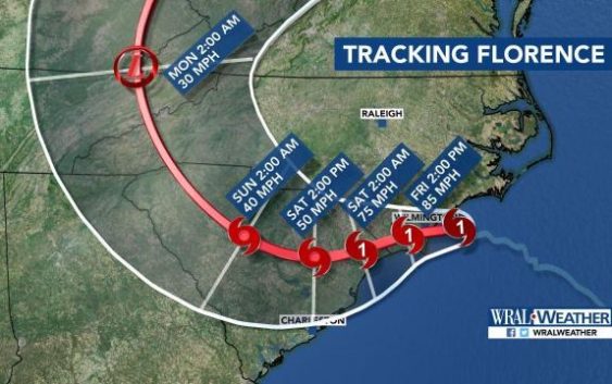
Hurricane Florence made landfall in Wilmington Friday morning as a Category 1 storm.
The Triangle will feel the strongest effects from Florence after 8 a.m.
The latest updates from our viewing area:
8:04 a.m.: The statewide power outage has jumped to 403,000.
8 a.m.: A flash flood warning is in effect for Wayne and Wilson counties until 2 p.m.
7:56 a.m.: Greenville was seeing heavy rain and officials say the Tar River is at risk for flooding.
7:36 a.m.: The heaviest rain in Raleigh will be around noon, Gardner said. By 5 p.m., the rain bands will be moving north.
7:23 a.m.: A homeowner in Durham has reported a large tree down in his yard.
7:09 a.m.: Two storm-related injuries have been reported in Edgecombe County. Gov. Roy Cooper said no storm-related deaths have been reported in North Carolina.
7:01 a.m.: The National Weather Service has issued a tornado watch for most of our viewing area, including Wake, Edgecombe, Franklin, Harnett Johnston, Nash, Sampson, Wayne and Wilson counties. This means the conditions are right for a tornado to form. The tornadoes may be weak and short-lived but can cause significant damage.
6:58 a.m.: Impacts from Florence are beginning to show around the Triangle, including heavy rain and tropical storm force winds. “If you are heading out, be careful,” said WRAL Brian Shrader. “The worst is yet to come.”
By Friday afternoon, the Triangle’s roads could see flooding.
6:38 a.m.: A flood advisory has been issued for Johnston, Wilson, Harnett and Edgecombe counties, meaning there is minor flooding reported in the area. Wake County is currently under a flash flood watch.
6:29 a.m.: The City of Raleigh is tweeting out important reminders to citizens. The non-emergency call center for Hurricane Florence is 919-996-2999.
6:07 a.m.: Trees are down in Johnston County due to rain bands and heavy winds moving through the area. The top wind gusts were reported in Raleigh are at 39 mph. Winds will continue to increase throughout the day and will remain strong for much of Saturday. Rain could continue through Tuesday.
6 a.m.: The eyewall of Hurricane Florence is onshore on North Carolina and landfall is expected soon near Topsail Beach.
5:22 a.m.: More than 550 people are currently in seven shelters in Cumberland County.
5:05 a.m.: Over 8,000 customers are now without power in Wake County.
5 a.m.: The latest update from the National Hurricane Center shows little change to Florence’s path or strength. The Category 1 storm has maximum sustained winds of 90 mph and is moving slowly, at 6 mph.
4:49 p.m.: 50 mph wind gusts have been reported in Cumberland County, where some trees are down. Fayetteville could see up to 15 inches of rain and wind gusts up to 80 mph.

4:44 a.m.: Isolated tornadoes are likely in our viewing area this morning as Florence narrows in on the coast. Wake County is not yet under a tornado watch, but it will remain under a flash flood watch until 8 p.m. Sunday and a tropical storm warning until further notice.
4:37 a.m.: A whopping 280,000 customers are without power in North Carolina. The highest numbers are being reported in New Hanover County.
4 a.m.: The Triangle is already seeing some strong winds, with gusts of 40 or 45 being reported in Raleigh. “From 8 a.m. to noon, the center will drift inland across southern North Carolina, and that is when we will see the strongest winds,” said WRAL meteorologist Elizabeth Gardner.
3:39 a.m.: Winds were beginning to pick up in Wake County and about 50 power outages have been reported in Cary, but crews were responding to reports quickly.
3:33 a.m.: The number of power outages reported across the state has actually decreased, with state officials saying 180,096 customers are without power. That number is about 5,000 less than what was reported by state officials an hour ago.