- Houston Cougars take on A&M Aggies in charity exhibition game supporting Hurricane Beryl relief
- Hurricane Helene donations delivered to Avery County for Share the Warmth campaign
- Old Crow Medicine Show founder talks music, hurricane relief and this weekend's big benefit show
- IV fluid shortage caused by hurricane to last for months
- 'It financially annihilated us': Pregnant mother displaced for 2nd time after western NC floods
The latest: Flash flood warning extended for Wake County
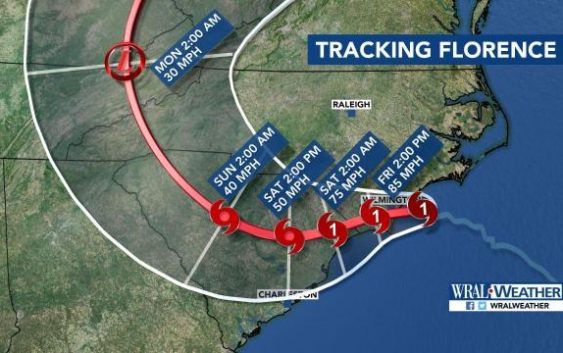
Tropical Storm Florence is continuing to drop torrential rain across the state Saturday as the system moves into South Carolina. While clean-up has started in many areas, water rescues are still underway and hundreds of people are still in survival mode.
At a glance:
- Many North Carolina residents are dealing with flooding after Florence made landfall Thursday as a Category 1 storm Friday.
- Florence was downgraded to a Tropical Storm late Friday.
- More than 814,000 customers are without power in North Carolina.
- Seven deaths – a woman in Pender County, a mother and child in Wilmington, two people in Lenoir County and two people in Carteret County – have been blamed on the storm.
- More than 100 people have been rescued in New Bern, and water rescues were being reported in Jacksonville, North Carolina on Saturday.
Latest updates
10:40 a.m.: Flash flood warnings that were in effect for many central North Carolina counties, including Wake, have been extended until 5 p.m. Many counties south and east of Wake will remain under a flash flood watch Saturday evening and into early next week.
10:30 a.m.: Authorities have closed all northbound and southbound lanes of I-95 between Fayetteville and Dunn due to flooding.
According to the Fayetteville Police Department, power lines and a tree are covering Skye Drive off Morganton Road. “Just stay home,” police tweeted.
Public utilities trucks from the City of Raleigh will deploy to Fayetteville to assist with sewer service restoration. Four two-man crews and four vacuum trucks will be used.
Residents in Carolina Beach are under a mandatory boil water notice. According to the N.C. Division of Environmental Health, water used for drinking, cooking, brushing teeth, making ice and washing hands should be boiled before it is used. Officials say 1-2 minutes of rigorous boiling is sufficient.next week.
9:44 a.m.: State officials said 814,351 people in the state are without power.
9:35 a.m.: Authorities in Jacksonville said 20 people were rescued from an apartment on West Francis Street overnight after water began rising in the building. Four others were rescued at private homes and four people were rescued from vehicles.
9:25 a.m.: President Donald Trump declared a major disaster in the state of North Carolina and ordered federal aid to supplement recovery efforts. The action makes federal funding available to Beaufort, Brunswick, Carteret, Craven, New Hanover, Onslow, Pamlico and Pender counties.
The federal assistance can include grants for temporary housing and home repairs, low-cost loans to covered uninsured property loss and other programs to aid recovery.
9:20 a.m.: Southbound lanes of Interstate 95 were closed between Dunn (Exit 71) and Exit 64 due to flooding. The road is expected to reopen by 8:30 a.m. Monday.
Motorists must use Exit 70 (Bud Hawkins Road) to access US-301 South. Drivers should then continue on US-301 South to NC-82 East and continue on NC-82 to I-95.
9:05 a.m.: State officials said 820,851 people were without power as a result of Florence.
8:57 a.m.: Apex officials said a portion of Richardson Road is closed due to flooding at the bridge over Beaver Creek. Drivers are advised to avoid the area.
8:44 a.m.: Harnett County has declared a mandatory evacuation along the Lower Little River near the Cumberland County line. Officials said the National Weather Service is predicting the Lower Little River will crest at 35.4 feet Monday morning, which is 17 feet above flood stage.
Emergency officials were going door-to-door Saturday to advise residents of the evacuation. The county will open Western Harnett High School at 10637 N.C. Highway 27 in Lillington at noon to accommodate evacuees.
Residents are asked to evacuate by 5 p.m.
8:41 a.m.: WRAL meteorologist Elizabeth Gardner said that Wayne County, particularly in the Goldsboro area, have seen the highest rainfall totals so far, with 10 to 15 inches. She said the Neuse River is likely to reach near-record flood levels by next week but the Tar River, which caused devastation during Hurricane Matthew, will only experience minor flooding.
8:37 a.m.: North Carolina Emergency Management said that 813,519 people are without power across the state with the most outages reported in New Hanover, Brunswick, Columbus, Craven, Duplin, Onslow, Carteret, Cumberland, Moore, Robeson, Sampson and Wake counties.
8:36 a.m.: Authorities said the 911 system is out across Onslow County, which is hindering water rescues that are necessary after overnight flooding. Officials said most roads in the county are impassable because of downed trees and power lines.
8:26 a.m.: Cumberland County officials said a decision will be made early Saturday afternoon about whether or not to place a limited area of the county and the City of Fayetteville under mandatory evacuation orders. Residents who live within one mile of the Little River or Cape Fear River are encouraged to voluntarily evacuate because of teh potential for flooding.
Officials said that 681 people remain at seven emergency shelters, although two of those shelters are without power.
8:25 a.m.: Chatham County officials said that the number of people in shelters in the county is declining, with only 39 evacuees Saturday morning. About 6,100 people in the county remain without power.
8:14 a.m.: A stretch of Interstate 40 between exits 364 and 369 were closed in Wilmington as a result of flooding from Tropical Storm Florence. The road is expected to reopen by Monday.
7:59 a.m.: Sampson County officials said one person was rescued when a vehicle tried to go through high water. The person was safe and the vehicle was moved to the side of the road.
7:43 a.m.:Officials in Jacksonville are looking for volunteers with flat-bottomed, Jon boats to assist the city’s water rescue team as crews work to rescue people trapped in their homes following flooding. Anybody who can offer a boat to assist should cal 910-938-5200,
7:39 a.m.: A high water rescue was reported in Newton Grove in SampsonCounty as a flash flood emergency was issued for southwestern Wayne, northern Sampson and south central Johnston counties.
Locations that will likely experience flooding include Mount Olive, Newton Grove, Turkey, Hobbton and Spivey’s Corner.
7:16 a.m.: Crabtree Creek was rising in Raleigh and although it has not reached flood stage, a flash flood warning remains in effect until 11 a.m.
7:02 a.m.: A tornado watch has been extended until 5 p.m. for several counties, including Johnston, Harnett, Sampson, Wilson, Wayne, Cumberland and Hoke.
6:56 a.m.: Officials with the City of Raleigh said more than 65 trees have fallen on city roads.
6:42 a.m.: There are still 786,769 customers without power across North Carolina with the highest number of outages reported in New Hanover, Brunswick, Onslow, Carteret, Cumberland, Robeson, Sampson and Wake counties.
6:31 a.m.: Stephen Rea, director of the Carteret County Emergency Services, said two people died Friday morning on Harkers Island as a result of Florence. Authorities did not say how the people died. The total number of deaths caused by the storm now stands at seven.
6:15 a.m.: WRAL meteorologist Elizabeth Gardner said that rain conditions for parts of the viewing area could be worse Saturday than they were Friday. The continuing rain, combined with wind gusts, could lead to more downed trees and power lines.
“Areas that have power now may not have power by the end of the day,” she said.
6:08 a.m.: A flood advisory has been issued for Wake, Orange, Moore, Lee, Durham and Alamance counties until noon Saturday.
6:07 a.m.: State officials said 782,909 people remain without power.
6 a.m.: The National Hurricane Center said life-threatening storm surge is expected to continue along the North Carolina coast and tropical storm conditions will continue along the coast and inland.
5:49 a.m.: WRAL meteorologist Elizabeth Gardner said some southern counties could continue to see 1 to 2 inches of rain per hour Saturday.
5:38 a.m.: Lindsey Listrom with the North Carolina Electric Cooperatives, which handles power outages for 93 of the state’s 100 counties, said crews are in place, but need to wait for conditions to improve to begin power restoration.
“Conditions can really delay the start of our crews working because we have to make sure our crews are safe,” she said. “We’re just monitoring the storm and as soon as the teams can get in and make repairs, they’ll do that.”
5:26 a.m.:With downed trees, downed power lines and power outages, the New Hanover County sheriff is calling the aftermath of Florence “an absolutely dangerous situation.” A county-wide curfew remains in effect until 6 a.m.
5:21 a.m.: A Facebook post from officials at Cape Lookout National Seashore shows that the only road onto Harkers Island has been significantly damaged by Florence. The North Carolina Department of Transportation is aware of the issue and will try to find a solution Saturday, officials said.
5:20 a.m.: A tornado warning has been canceled for Wayne County.
5:13 a.m.: The Cross Creek in Fayetteville is beginning to swell as water approached the banks. The creek feeds into the Cape Fear River, which is expected to reach flood stage sometime next week as a result of rainfall from Florence.
5:04 a.m.: Officials said 780,390 are without power across the state.
5:03 a.m.: A tornado warning has been issued for Wayne County until 5:45 a.m. A tornado warning issued for Lenoir County has been allowed to expire.
4:56 p.m.: Tropical storm warnings have been canceled for Franklin, Nash and Edgecombe counties.The warning remains in effect for Chatham, Cumberland, Harnett, Hoke, Johnston, Lee, Moore, Richmond, Sampson, Scotland, Wake, Wayne and Wilson counties.
4:45 a.m.: Flood waters are beginning to recede in New Bern, where hundreds of people had to be rescued Friday as portions of the city were under water.
Rain in New Bern has stopped, at least for the time being, and the focus will soon shift to cleaning up the downed trees and power lines.
4:38 a.m.: Durham Drive is closed in Raleigh as flood waters washed over the road.
4:37 a.m.: A tornado warning is in effect for Lenoir County until 5 a.m.
4:33 a.m.: WRAL meteorologist Elizabeth Gardner said that even though the center of Tropical Storm Florence is in South Carolina,North Carolina will continue to get the brunt of rain from the system, especially in the southern counties.
4:30 a.m.: According to NOAA, the Neuse River at Kinston could reach near-record levels by mid-week and may continue to climb.
4:22 a.m.: WRAL meteorologist Elizabeth Gardner said an additional 5 inches of rain are possible throughout the day Saturday in Raleigh and an additional 9 inches of rain are possible in Fayetteville.
Gardner said the Cape Fear River, which is currently at 2.4 feet is likely to reach 22.9 feet by Monday. Flood stage for the river is 14 feet.
4:12 a.m.: At least 170 roads are fully or partially closed in Wilmington as a result of downed trees and power lines.
4:09 a.m.: Crews with the Fairview Fire Department were working to move a massive tree that was blocking the intersection of Cedric Drive and Woodmill Run in Wake County. The road is the only way in or out of a nearby neighborhood.
4 a.m.: WRAL meteorologist Mike Moss said that Tropical Storm Florence is continuing to move southwest at 5 mph and has sustained winds of 60 mph.
“With the wet ground and the heavy rain that could still occur, that could lead to some trees down and maybe even some power outages,” Moss said.
The center of the storm is over eastern South Carolina, but rain is continuing to fall throughout the state and is particularly heavy in the southern counties.
Since midnight, peak wind gusts reached 32 mph in Raleigh and 47 mph in Fayetteville. For the remainder of the day, wind gusts could reach about 38 mph in Wake County and up to 50 mph in southern counties. Those speeds will remain consistent until winds die down Sunday.
Moss said a tornado watch remains in effect for counties to the south and east of the Triangle until 7 a.m. and tropical storm warnings remain in effect for a large portion of the state.