- EF-1 tornadoes ripped through Cypress, Waller County areas with winds at more than 100 mph, NWS reports
- Houston-area storm damage updates: Clean up continues after NWS says two EF-1 tornadoes and powerful derecho ripped through SE Texas
- Low risk of damaging winds, hail from Saturday storms
- EF 1 tornadoes ripped through Cypress, Waller County areas at more than 100 mph, NWS reports
- Caddo Mounds State Historic Site to celebrate new visitor center, traditional grass house after 2019 tornado
Cheraw, already deluged with rain, braces for more flooding from Great Pee Dee River
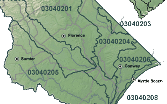
A pounding rain smacked this town near the North Carolina border Sunday for the third straight day, creating miserable conditions and raising concern that the Great Pee Dee River would soon flood the area.
The river, which flows out of North Carolina, is forecast to spill its banks this week, rising to near record levels. Dams upriver were expected to release water as rain from former Hurricane Florence swelled the Yadkin River, a North Carolina waterway that becomes the Great Pee Dee in South Carolina.
On the Great Pee Dee, river levels will reach 49 feet by Tuesday, about one foot short of the record flood level, according to the National Weather Service. Running through the heart of eastern South Carolina, the Great Pee Dee River extends from the state line to Winyah Bay at Georgetown. High water is expected later in Georgetown.
Flash flooding already had swamped Cheraw. As of mid-day Sunday, numerous intersections were under water. Water more than a foot deep stood in the intersection next to J.J. Wallace’s white frame home, as he rocked on the porch and thought about what had happened to his hometown. The intersection looked more like a small pond than a roadway.
Wallace, 46, said he’s seen flooding before, but worried that more rain would make matters worse. His home sits on a slight rise, just above the flooded intersection.
“This flooding is equal to anything I’ve seen since I’ve been here,’’ said Wallace, who moved into his house in 1995. “If a few more bands (of rain) come through, it’s going to be more than I’ve ever seen.’’
Wallace’s house had just had power restored early Sunday afternoon, but his neighbors were still in the dark because of the storm. His 15-year-old son, Alan, took a care package to neighbors who still did not have power. The package included battery operated video games for children to play with.
Brian Broughton, chief executive at Lynches River Electric, said thousands of homes remain without power in areas his company serves from Kershaw County to Chesterfield County. He said most power should be restored by Sunday night.
But it hasn’t been easy for work crews.
“We are in a monsoon right now,” Broughton said Sunday morning.
High winds and rain have been constant in the area through much of the weekend, he said. It was becoming increasingly difficult to maneuver through muddy, flooded areas, he said. His company was bringing in heavy machinery to maneuver through the muck, he said. By Sunday afternoon, the driving rain had dropped to sprinkles, but it picked up again later.
One report from WBTV indicated there were concerns that a local dam might break. Wallace said the dam is near a nursing home.
“This area has been hit pretty hard,” Broughton said. “I have never seen it rain this much. It doesn’t look like we are going to be out of it for a while.”
The cooperative serves Chesterfield, Lancaster and Kershaw counties. It has 20,000 customers. Local officials have instituted a curfew that was to take effect Sunday night.
Harold Haney, Chesterfield County’s emergency services director, said winds dropped substantially Sunday. But he said the amount of water pouring into the area appears worse than either a historic 2015 flood associated with Hurricane Joaquin or Hurricane Matthew in 2016. Many roads are washed out.
An assisted living center was evacuated to avoid flooding, he said.
“The water is way more,’’ he said.
Areas near Cheraw showed signs of problems, althugh the rain was not as heavy. Farm fields contained standing water on U.S. 1 in Kershaw County near Bethune.