- Houston Cougars take on A&M Aggies in charity exhibition game supporting Hurricane Beryl relief
- Hurricane Helene donations delivered to Avery County for Share the Warmth campaign
- Old Crow Medicine Show founder talks music, hurricane relief and this weekend's big benefit show
- IV fluid shortage caused by hurricane to last for months
- 'It financially annihilated us': Pregnant mother displaced for 2nd time after western NC floods
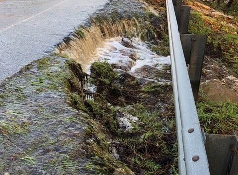
HURRICANE FLORENCE: Rising floodwaters make Wilmington an island again
Flooding closes US 421, which was backed up with traffic for miles Wednesday
SOUTHEASTERN N.C. — New Hanover County became an island again Thursday morning, as state officials closed U.S. 421 after portions of the road on the New Hanover and Pender county line flooded.
“At this time no safe, stable or reliable route exists for the public to get to and from Wilmington,” the N.C. Department of Transportation (DOT) said in an advisory Thursday morning.
The closure came after the road was identified as one of the few entry points into the county, along with U.S. 17 from the north. But with flood waters rising north of New Hanover County, U.S. 17 could also be compromised, said Karen Collette, division engineer for the DOT region that includes Southeastern North Carolina.
“The waters are still rising, receding and moving,” she said. “This is a fluid situation.”
On Wednesday, incoming traffic on U.S. 421 saw cars backed up for 11 miles, Collette said.
Much of the traffic was people trying to return to the Wilmington region after having left for places inland as Hurricane Florence approached. But Collette said the two-lane route wasn’t built to handle traffic she said was akin to Azalea Festival weekend’s influx that is usually brought to the region on Interstate 40.
But with several miles of I-40 closed, U.S. 421 became choked with cars, she said.
“That road was not designed to carry (the equivalent of) three lanes of traffic on one lane,” she said.
Collette, who said transportation officials are trying to find a new route into Wilmington for utility crews, supply runs and emergency vehicles, echoed the call local and state officials have said for the last several days: if you are in a safe place inland, stay there.
“We need supplies, gas, food, power companies,” she said. “We need that transportation system open so that, when the general public gets here,” things like gasoline, power and groceries will be available.
Collette said officials don’t know when I-40 will be reopened.
“We’re not sure when we’re even going to see pavement yet,” she said.
Even when the waters recede, she said, the road likely will be severely damaged and need repairs.
“It’s been under water for a week or so,” Collette said. “There most likely will be major repairs to I-40 even when we can see the pavement.”
In Pender County, the ever-rising Northeast Cape Fear River near Burgaw — it was at more than 25 feet Wednesday night, shattering its previous record depth of 22.5 feet — has seen several miles of Route 53 closed.
“12 miles of Highway 53 are underwater, in some cases 7 feet deep, between the Northeast Cape Fear bridge and Maple Hill. All homes including 60 in River Bend, 20 to 25 in River Birch and 12 in the Alligator Lake subdivision are flooded. 20 to 30 homes in Holly Shelter estates are underwater. In the Sandy Bend subdivision, off Shaw Highway, 40 to 50 homes, which is half of the homes in the subdivision sustain flooding. Portions of Croomsbridge, Island Creek and White Stocking Roads are underwater,” the National Weather Service said in a briefing late Wednesday.
Pender County Manager Randell Woodruff said Thursday morning that he could not get from the county’s annex in Hampstead to the emergency operations center in Burgaw because of flooded roads.
“The damages are very significant,” he said.
Reporter Tim Buckland can be reached at 910-343-2217 or Tim.Buckland@StarNewsOnilne.com.