- Houston Cougars take on A&M Aggies in charity exhibition game supporting Hurricane Beryl relief
- Hurricane Helene donations delivered to Avery County for Share the Warmth campaign
- Old Crow Medicine Show founder talks music, hurricane relief and this weekend's big benefit show
- IV fluid shortage caused by hurricane to last for months
- 'It financially annihilated us': Pregnant mother displaced for 2nd time after western NC floods
How will Tropical Storm Michael affect North Carolina?
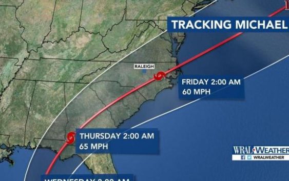
At a glance:
- TS Michael has winds of 70 mph and it could reach Category 2 strength by Tuesday.
- North Carolina and the Triangle could see up to 3 inches of rain, starting Wednesday into Thursday.
- Wind gusts in central North Carolina could reach 40 mph.
Tropical Storm Michael is expected to make landfall this week across the Florida Panhandle before moving up into Georgia and the Carolinas, dropping up to 3 inches of rain in parts of the Triangle late Wednesday into Thursday.
WRAL meteorologist Elizabeth Gardner said Monday that the National Hurricane Center’s 5 a.m. update on Monday has the storm making landfall as a Category 1 or Category 2 storm before moving up through the southeastern U.S.
“This is not going to be anything like Florence,” she said Monday. “It’s going to be fast moving and we’re not likely to see a lot of widespread flooding, but certainly minor flooding is a possibility.”
Gardner said the storm could bring tropical storm winds to the Triangle, with gusts of up to 40 miles per hour.
“We’re not talking about winds that will do a lot of damage but it will be windy and it will be rainy, starting on Wednesday into Thursday,” she said, but warned that downed trees and power lines could occur.
That means the opening day of the State Fair will likely be wet for those going on Thursday.
The forecast Monday calls for mostly dry, summer like weather although the day began with low clouds and fog reported in parts of the Triangle.
Gardner said once Michael has moved through the region, it will be dry and brisk, bringing a taste of true fall weather to central North Carolina.
Florida on alert
A tropical storm that rapidly formed off Mexico’s Yucatan Peninsula has gained new strength and could become a dangerous Category 2 hurricane with an expected midweek strike on the Gulf Coast in the Florida Panhandle, forecasts say.
")
Florida Gov. Rick Scott issued an order for a state of emergency for 26 counties to rush preparations in the Florida Panhandle and the Big Bend area, freeing up resources and activating 500 members of the Florida National Guard.
“This storm will be life-threatening and extremely dangerous,” Scott said Sunday after receiving a briefing at the State Emergency Operations Center. He warned that storm surge could affect areas of Florida not in the storm’s direct path.

Michael emerged Sunday as a tropical storm with winds of up to 50 mph (85 kph). But within hours Sunday it had gained more punch and its top sustained winds clocked in at 60 mph (95 kph) by late Sunday evening. The storm is expected to gain hurricane status by Monday night or Tuesday as its center moves over the Yucatan Channel and then crosses the Gulf of Mexico, nearing the Florida Panhandle coast by Wednesday.

The storm was located by 2 a.m. ET Monday about 105 miles (170 kilometers) east-southeast of Cozumel, Mexico, and moving to the north at about 4 mph (6 kph). Tropical storm winds extended out 170 miles (275 kilometers), primarily to the northeast and southeast of the storm’s center.
Forecasters advised residents along the northeastern and central U.S. Gulf Coast to monitor the storm’s progress.
The north Florida city of Tallahassee on Sunday opened two locations where residents could get sandbags in case of flooding.
“While the impacts are still uncertain, our area could experience increased wind activity and heavy rainfall, which could cause localized flooding and downed trees,” Tallahassee officials said in a statement.
Tallahassee Mayor Andrew Gillum, who is the Democratic nominee for govern