- Severe weather leads to fallen trees, car crashes and flooding around the Triangle
- New video shows vehicles being swept away in historic, deadly flash floods in SA on June 12
- $40 million to go to underserved SC counties for Hurricane Helene recovery. Here's what you need to know.
- Family honors Air Force veteran Derwin Anderson Jr. after he died in June flash floods
- City of Wilmington addresses flooding on New Centre Drive
Tropical storm warning issued for Midlands ahead of Hurricane Michael
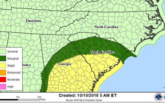
The entire Midlands area is under a tropical storm warning ahead of an impact from Hurricane Michael, now a Category 4 storm.
The warning was issued just after 5 a.m. Wednesday by the National Weather Service and extends west across the Georgia state line . A tropical storm warning means tropical storm-force winds are expected in an area within the next 36 hours, according to the weather service. The area remains under a flash flood watch.
Michael was upgraded to an “extremely dangerous” Category 4 hurricane early Wednesday by the National Hurricane Center and, after making landfall on the Florida coast sometime Wednesday, is expected to barrel through the Carolinas.
Forecasters are predicting 4 to 6 inches of rain with locally higher amounts, but wind continues to be the primary concern for weather and emergency officials.
Columbia-area residents can expect to start feeling the wind effects around 6 or 7 a.m. Thursday, said Mike Proud, a meteorologist with the National Weather Service in Columbia.
As the storm rolls through and heads northeast, it’s going to accelerate, creating a risk for tornadoes, Proud said. The area of the greatest risk will be along the corridor from Augusta to Columbia to Cheraw, and everything east of that will be at a slightly higher risk, Proud said.
“They will be expecting some tornado watches to go up late tonight into Thursday morning in advance of that threat,” Proud said, referring to the storm prediction center.
Winds will die down between 11 a.m. and 1 p.m. Thursday, which Proud said will be the eye of the storm moving through. The storm is expected to move through the area quickly, and winds should begin tapering off around 8 p.m. Thursday, Proud said.
“We’ll have some high winds through the morning, a little break, and then some high winds through the afternoon into the evening hours,” he said.
Most of South Carolina was under a marginal or slight risk for severe thunderstorms early Wednesday.
The latest local forecast for the Columbia area predicts winds below tropical storm force between 20 and 30 mph with gusts of 40 mph; however, forecasters say there also the potential for winds of 58 to 73 mph capable of threatening life and property.
Power companies across the Palmetto State are bracing for outages from a hit by Michael, and several school districts have ordered early dismissals Wednesday and cancellations Thursday.
Check back for updates.