- Houston Cougars take on A&M Aggies in charity exhibition game supporting Hurricane Beryl relief
- Hurricane Helene donations delivered to Avery County for Share the Warmth campaign
- Old Crow Medicine Show founder talks music, hurricane relief and this weekend's big benefit show
- IV fluid shortage caused by hurricane to last for months
- 'It financially annihilated us': Pregnant mother displaced for 2nd time after western NC floods
Higher temps expected Saturday with tornado watch to the north
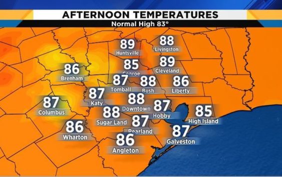
HOUSTON – Look for highs Saturday to be well above normal with many locations reaching the 88 and 89-degree mark.
There are slim chances of showers for the main Houston metro, but not so for areas to the north and west of Houston, where an unsettled atmosphere is leading toward 50-60 percent rain chances. There is a tornado watch in place until 6 p.m. for more than 20 counties in Central Texas.
The remnant low of what was Tropical Storm Sergio is moving along a stationary boundary from west to east and that is what is causing the watch.
Changes are coming late Sunday into Monday as a cold front slides south, bringing cooler temperatures and rain. There will be a 27-degree temperature drop from the highs of this weekend to the highs in the low to mid-60s on Tuesday.
Look for showers to stick around all week along with lower than normal high temperatures in the mid-60s to low 70s.
Khambrel
Copyright 2018 by KPRC Click2Houston – All rights reserved.