- WATCH: Video Shows Confirmed Tornado touches down in Columbus County
- Residents begin clean up after storms, apparent tornado roll through NC Tuesday
- Flooding lingers in Liberty County neighborhoods near Trinity River with more rainfall expected
- North Carolina behind on hurricane preparedness, study shows
- North Carolina way behind on hurricane preparedness, study shows
Warnings and watches in the Hill Country
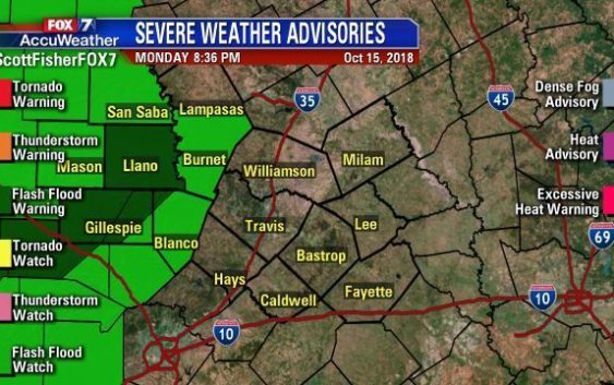
From a heat index of 101 degrees to a wind chill at 38 degrees, a powerful cold front has chilled down all of Texas.
Along with the cold air, rain has been around most of Monday and Flash Flood Watches and Warnings are up for the Hill Country.
The Llano River at Llano has reached moderate flood stage and the Lower Colorado River Authority has opened floodgates at both Starcke and Wirtz Dams. If you live downstream of those, now is the time to prepare your home for possible flooding, and if needed evacuate.
Many reports of standing water are coming in and roads will be or already are closed. Stay up to date with ATXfloods.com.
Llano ISD and Burnet CISD will have a two-hour delay Tuesday morning.
The cold air will stay locked in place for several days and with warm air riding up and over the cold air at the surface, that will keep the clouds and showers around for several more days.
Please stay weather aware as flood waters can rise VERY QUICKLY!
Remember: Turn Around, Don’t Drown!