- Southport hosts annual Hurricane Expo ahead of the 2024 season
- How to protect your car before a hailstorm
- ‘We lost everything’: East Texas residents confront their future after flooding
- Here's how to get your flooding debris picked up by the City of Houston
- Mosquito activity on the rise due to rainfall, flooding across Texas
Strong storms with damaging winds, tornadoes possible on Election Day in the Carolinas
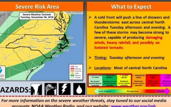
Election Day in the Carolinas could be a soggy one, and there’s a chance of severe storms as voters head to the polls.
A strong cold front is pushing a line of showers and thunderstorms ahead of it east and is expected to move into North and South Carolina Tuesday, reaching the central part of both states by Tuesday afternoon and evening, according to the National Weather Service.
Some of those storms could strengthen and become severe — “producing damaging winds, heavy rainfall and possibly an isolated tornado,” the weather service’s Raleigh office said.
Storms could begin to move into western North Carolina and much of western and central South Carolina beginning Tuesday morning, and will reach the Triad area of North Carolina around noon, NWS Raleigh meteorologist Kathleen Carroll told The News & Observer Monday. The Triangle area and eastern South Carolina could see the storms move in closer to 3 or 4 p.m., Carroll said. North Carolina’s coast likely won’t see storms until Tuesday evening.
The intensity of Tuesday’s storms will depend on how warm in gets, and how clear skies are ahead of the cold front, Carroll said.
Parts of western North Carolina and the Triad could see less severe storms, while the Triangle and areas east of Interstate 95 could see stronger storms, she said.
But the main threat to voters in the Carolinas will be “periods of heavy rain” and the possible thunderstorms that could make waiting at the polls miserable, or potentially dangerous.
“People should probably bring a rain jacket or poncho with them when they go vote,” Carroll said. “And maybe an umbrella, though heavy winds could make that a hazard. Just be prepared to get wet.”
Since wind gusts could reach 25 mph or higher in North Carolina as storms strengthen, Carroll said people should “monitor the weather when they head to the polls” and have a plan to get inside if things worsen.
Straight-line wind gusts from severe storms could reach 60-70 mph, NWS Columbia meteorologist Doug Anderson told The State, which could damage trees or power lines.
“The strongest weather will be in (South Carolina’s) Upstate, but its southern edge will be in Columbia and the Midlands and move in a northeast direction up through Charlotte and Raleigh,” Anderson said.
A dense fog also was possible for Monday night in the Columbia, S.C. area, the weather service reported. A fog advisory may be issued.
The same cold front heading into the Carolinas Tuesday was moving over other parts of the South Monday, bringing “strong winds, large hail and tornadoes” according to the weather service.
“A significant severe weather outbreak is forecast to intensify Monday night with potential for very large tornadoes EF-2 or greater possible,” the weather service said.
Election Day will be the warmest day of the week across the Carolinas, with temperatures “rising into the 70s,” ABC11 meteorologists reported Monday.
While the advancing cold front will bring storms and the potential for a heavy downpour, ABC11 meteorologists said people shouldn’t expect “more than one or two hours of rainfall.”