- Kerr County floods: At least 68 dead, including 28 children, as searches continue in Hill Country
- Military drone controlled in Houston helping search and rescue in Hill Country floods
- North Texas sisters among those killed in Hill Country flooding, their grandparents are still missing
- Flooding, tornado warnings make mess for NC residents as Chantal moves through
- Gov. Abbott provides update on Central Texas flooding, says Texas has been approved for federal aid
Cool, cloudy break today before Thursday flood watch
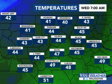
Raleigh, N.C. — You might see some sprinkles or light showers during the morning commute, but compared to the rest of this week, Wednesday will be mostly clear.
According to WRAL meteorologist Mike Moss, most of the sprinkles will diminish by 9 or 10 a.m., but the day will stay cloudy and cool with temperatures in the 40s.
After an overcast day, persistent rain will return for Thursday. Much of the viewing area, including the Triangle, is under a flood watch starting Wednesday night through Thursday, when the rain is really expected to pick up.
“Rain chances and intensity ramp back up later tonight through midday Thursday before tapering back to patchy light rain Thursday afternoon and evening,” said Moss. “Amounts in that time frame could range from around .5 inch to 2 inches, and there could be a few intense thunderstorms toward the coast late morning into the afternoon.”
The good news is that the weekend will be pleasant, with highs at least 10 degrees warmer than they were Wednesday and Thursday.
Friday will be sunnier with a high in the mid 50s, and Saturday and Sunday should be mild with highs in the upper 50s to low 60s. Rain will not be a threat on Saturday for the Raleigh Christmas Parade and Winter Wonderland.
