- Whiteville resident recalls events from Tuesday nights tornado
- Tornado damage reported in southern NC after Tuesday's severe storms
- If your home floods, here are steps you can take to address mold
- WATCH: Video Shows Confirmed Tornado touches down in Columbus County
- Residents begin clean up after storms, apparent tornado roll through NC Tuesday
Flood watch continues as Lake Wylie, others, rise. More storms, rain could be coming.
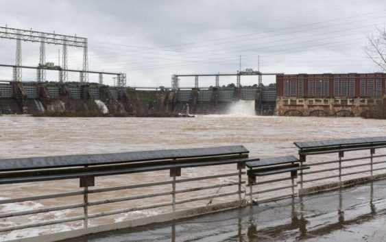
Lake Wylie is up a foot in two days, lakes upstream and downstream are spilling and it isn’t clear yet just how high waters will rise from heavy rain in this basin.
On Friday morning, Duke Energy issued a new round of notifications warning residents and recreational users along Catawba River lakes to use caution. Duke manages the 11-reservoir system and uses it for power generation. The latest notifications state a major lake downstream of Wylie could spill its shores by up to three feet.
The Friday morning message for Lake Wylie reads:
“The Catawba River Basin is experiencing increased runoff from the significant rainfall received in the upper region of the basin. The Duke Energy hydro operations team is aggressively moving water through the river system and spillway gates are still open at Wylie, Fishing Creek and Cedar Creek hydro stations. Lake Wateree is spilling but is not expected to exceed 103 ft. Lake level predictions will be hard to determine until the rain has ended and stream flows are no longer rising. We will provide updates as conditions change. As always, we encourage residents living along lakes, streams and other lower lying and flood-prone areas to pay special attention to changing weather conditions and take any necessary precautions.”
$20 for 365 Days of Unlimited Digital Access
Last chance to take advantage of our best offer of the year! Act now!
#ReadLocal
The message comes three days after a similar warning from Duke. On Christmas, Duke warned of heavy rain forecast and water running from dams to make way for it. By Wednesday, four of the 11 reservoirs topped out above full pond, or their flood stage.
Lake Wylie sat just below its target level on Wednesday, but by Friday morning was about a foot higher. Wylie has more than two feet before it reaches its full pond. Wylie is one of the more protected lakes from flooding, centrally located on the chain and near the massive Lake Norman which, like Wylie, is big enough to help even out the entire system by holding or releasing water.
Still, even Wylie faces flooding danger. As recently as Dec. 22 Wylie sat within half a foot of full pond.
In the past week, lakes James, Rhodhiss, Lookout Shoals, Wateree and Mountain Island Lake all exceeded their full pond levels, while Norman came within an inch of it.
The National Weather Service issued a flood watch for York and host of other counties through Saturday morning. It notes potential heavy rain Friday night. Moisture from the Gulf of Mexico streaming across the western Carolinas and northeast Georgia comes ahead of a cold front moving eastward.
“Soils remain nearly saturated from recent snowmelt and rainfall, and many area streams and reservoirs are already running at high levels, posing an increased risk of flooding,” reads the flood watch notice. “Heavy rain and a few embedded thunderstorms will arrive with the cold front this afternoon and the associated higher rainfall rates could quickly worsen ongoing flooding.
While rainfall on Lake Wylie affects its lake level and flood risk, so too does rain upstream in the Catawba basin. Many of those North Carolina counties join York in the flood watch, having already received significant rain in recent days.
Check back for more.