- 'She will be greatly missed': Memorial service held for 77-year-old woman killed in SA floods on June 12
- San Antonio officials warn residents to stay vigilant ahead of possible Thursday nights floods
- Flood Watch issued for counties west of San Antonio | Weather Impact Alert
- Possible heavy downpours and flooding in Hill Country counties | Weather Impact Alert
- Severe weather leads to fallen trees, car crashes and flooding around the Triangle
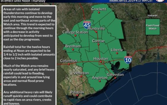
Flash flood watch in effect until noon
-
Southeast Texas is under a flash flood watch until noon on Thursday, Jan. 3, 2019.
Southeast Texas is under a flash flood watch until noon on Thursday, Jan. 3, 2019.
Photo: National Weather Service Houston/Galveston
Southeast Texas is under a flash flood watch until noon on Thursday, Jan. 3, 2019.
Southeast Texas is under a flash flood watch until noon on Thursday, Jan. 3, 2019.
Photo: National Weather Service Houston/Galveston
A flash flood watch will last until noon in southeast Texas, with rain activity expected to dwindle as the day continues.
Flooding is expected until 6:30 a.m. in parts of Montgomery County, northwestern Fort Bend County, Waller County, west central Liberty County and northwestern Harris County, according to the National Weather Service.
The rain and isolated thunderstorms are moving east and northeast, meteorologists said. By noon, 2 inches of rain will have been possible in the areas experiencing the heaviest rainfall.
Much of southwest Texas is already saturated with rainwater from the last couple of days, so any period of heavy rain could lead to flooding, meteorologists said.
In urban areas, street flooding and flooding of underpasses and low-lying areas is possible. Bayous and creeks could rise out of their banks, and rural areas could see flooding in low-lying areas, low water crossings and poor drainage areas, according to the National Weather Service. Rivers will also likely rise.