- EF-1 tornadoes ripped through Cypress, Waller County areas with winds at more than 100 mph, NWS reports
- Houston-area storm damage updates: Clean up continues after NWS says two EF-1 tornadoes and powerful derecho ripped through SE Texas
- Low risk of damaging winds, hail from Saturday storms
- EF 1 tornadoes ripped through Cypress, Waller County areas at more than 100 mph, NWS reports
- Caddo Mounds State Historic Site to celebrate new visitor center, traditional grass house after 2019 tornado
Blizzard cripples Rockies, tornado warnings hit Midwest; powerful storm not over yet
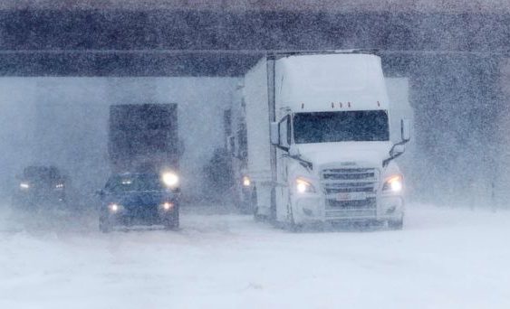
A massive storm crippled the Rockies and northern Plains with a powerful blizzard, dropping more than a foot of snow, closing interstates and stranding drivers.
As poor driving conditions overwhelmed Colorado roads, Colorado State Patrol Cpl. Daniel Groves was struck and killed by a car, officials said.
As the storm intensified Wednesday, a couple of preliminary record low pressures were recorded in Colorado and Kansas, forming one of the strongest storms to hit the High Plains in decades.
Nearly 80 million Americans are still at the mercy of this powerful storm Thursday as it brings dangerous blizzard conditions to the Rockies and Midwest, strong storms to Mississippi and Tennessee, and damaging winds to Texas, Arkansas and Louisiana.
There’s an enhanced risk for severe weather Thursday from Mississippi to Michigan, including Nashville, Louisville and Indianapolis and Cincinnati. Damaging winds, large hail and tornadoes are possible.
A tornado watch has been extended into portions of Kentucky, Illinois, Indiana and Ohio through the afternoon.
At least one tornado was also reported in Paducah, Kentucky, Thursday morning.
Winds over 50 mph are possible Thursday across much of the central U.S., from the Dakotas to Indianapolis to Chicago to St. Louis. Downed trees, power outages and property damage are possible.
There’s also a new severe component to this storm in the South. Thunderstorms and damaging wind gusts are possible in parts of Texas, Louisiana and Arkansas.
No significant severe weather is expected for most of the East Coast. There could be some strong wind gusts across parts of the Great Lakes into Thursday night; however, calmer and quieter weather should overtake much of the Northeast by Friday with only a couple of showers.
Copyright © 2019 ABC News Internet Ventures.