- Even light rain causing flash flooding issues on Houston's north side
- LIST: High water locations, street flooding as heavy rain falls in the Houston area
- China on Alert for Heavy Rain and Floods From Typhoon Gaemi
- Flash flood threat; A day to be Weather Aware
- Power-Thirsty Bitcoin Miners Are Flooding the Energy Center of Texas
Timeline: Hail, damaging winds possible this weekend with heavy rain likely
HOUSTON — Widespread strong to even severe thunderstorms are possible this weekend, warns KHOU 11 Meteorologist Chita Craft.
GET ALERTS ON THE GO: Download the KHOU 11 app
If you have outdoor plans, especially on Sunday, you may want to have a backup for indoors.

khou
Here’s what you can expect:
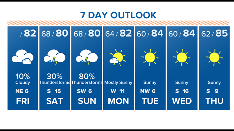
FRIDAY AFTERNOON AND NIGHT
Cloudy and in the mid to upper-70s most of the day today. A very light rain chance in the afternoon and evening hours.
SATURDAY MORNING
Saturday is still a little tricky to forecast, but at this point does not look like we will have any severe weather. It will be cloudy and in the low to mid-70s in the morning with a slight rain chance.
SATURDAY NIGHT
Cloudy conditions continue in the afternoon and evening with temps topping out at 80 degrees. Rain chances increase late in the day with storms possible in the late evening. Get prepared for storms as early as Saturday night, but expect the worst on Sunday at this point.
SUNDAY MORNING
Scattered thunderstorms are possible in the early-morning hours as cloudy conditions continue. Low-70s.
SUNDAY LUNCHTIME THROUGH THE AFTERNOON
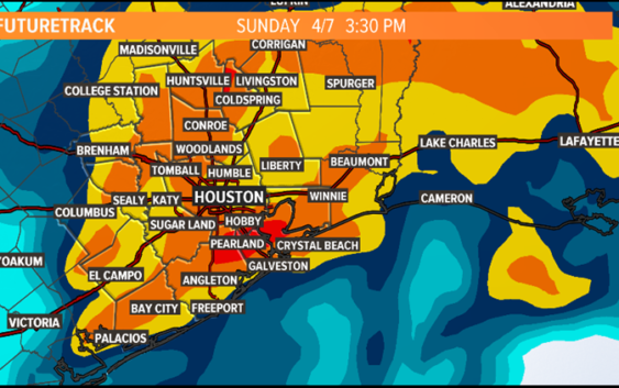
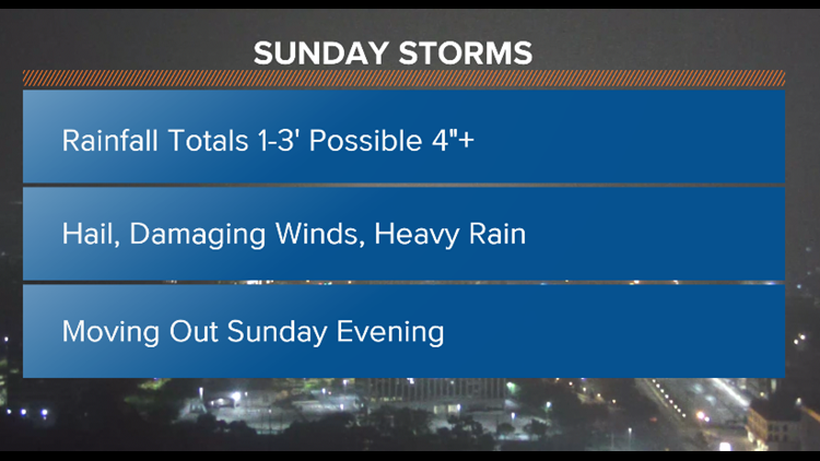
Much of the day looks like a total washout. 80 percent rain chance most of the day Sunday, especially midday into the afternoon. You need stay weather ready this weekend. Heavy downpours, possible hail, damaging winds and and the risk of an isolated tornado is not out of the question. Where the potential storms set up will almost be widespread. We’re not expecting massive citywide flooding, but we could see minor street flooding.
SUNDAY NIGHT
Rainfall totals of one to three inches of rain are likely through the afternoon with isolated areas of four inches possible. Moving out in the evening hours.
khou
Once we get through this weekend, next weekend looks amazing!
khou
ALSO POPULAR ON KHOU.COM: