- California wildfire burns out of control but firefighters could get a break when winds diminish
- 'Flooding is our number one natural disaster' | Breaking down the voter-approved Harris County Flood Control District tax rate hike
- Powerful Category 3 Hurricane Rafael knocks out power in Cuba as it heads to the island
- NC Forest Service warns of increased wildfire risk in western part of state after Helene
- First responders searched for hours after being told two people were swept away in flash flood
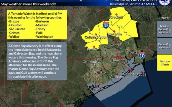
Tornado watch in effect north of the Houston area
-
A tornado watch is in effect for a swath of 10 counties north of the Houston area, including Walker and Grimes, while showers and thunderstorms continue to move across the region.
A tornado watch is in effect for a swath of 10 counties north of the Houston area, including Walker and Grimes, while showers and thunderstorms continue to move across the region.
Photo: National Weather Service
A tornado watch is in effect for a swath of 10 counties north of the Houston area, including Walker and Grimes, while showers and thunderstorms continue to move across the region.
A tornado watch is in effect for a swath of 10 counties north of the Houston area, including Walker and Grimes, while showers and thunderstorms continue to move across the region.
Photo: National Weather Service
A tornado watch is in effect for a swath of 10 counties north of the Houston area, including Walker and Grimes, while showers and thunderstorms continue to move across the region without directly hitting Houston.
Harris County residents should expect two to three inches of rain, according to the National Weather Service’s weekend forecast, which extends through Sunday night.
The service predicted similar rainfall levels in other nearby counties, with 1.5 to two inches likely to hit Galveston County. Along the Matagorda and Galveston Bay coast, a dense fog advisory is in effect through the late afternoon.
Forecasts for Sunday, meanwhile, show a slight risk of flash flooding in Houston and the counties surrounding Harris.
Only on HoustonChronicle.com: Warmer weather means time for swimming pool fun, and tragedies. Here’s some tips for swimming safely
Southeast Texas residents should stay on vigilant alert for hail and damaging winds, with a cluster of storms moving from SW to NE across much of SE Texas, from noon to 9:00 p.m. Another two inches of rainfall is possible, with potential for isolated higher amounts.
This is a developing story.
NEWS WHEN YOU NEED IT: Text CHRON to 77453 to receive breaking news alerts by text message | Sign up for breaking news alerts delivered to your email here.