- Flooding lingers in Liberty County neighborhoods near Trinity River with more rainfall expected
- North Carolina behind on hurricane preparedness, study shows
- North Carolina way behind on hurricane preparedness, study shows
- New hurricane preparedness report doesn't rank North Carolina well
- New hurricane preparedness report doesn't rank North Carolina well
Tornado watch remains in effect for several southeast Texas counties
HOUSTON — While we still anticipate the onslaught of thunderstorms and isolated severe weather, it appears that that threat has now shifted to be mainly a Sunday issue for southeast Texas.
CURRENT WATCHES AND WARNINGS
There’s a Tornado Watch in effect for Brazos, Burleson, Grimes, Houston, Madison, Polk, San Jacinto, Walker and Washington counties until 10 p.m.
GET ALERTS ON THE GO: Download the KHOU 11 app
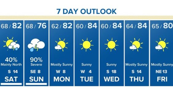
Here’s what you can expect the rest of the weekend:
SATURDAY WEATHER IN HOUSTON
The Storm Prediction Center has lowered our chances of severe weather on Saturday for most of southeast Texas but have increased the chance up towards Ark-La-Tex. All travel plans to Shreveport, east Texas or Arkansas should monitor the weather closely.
Locally, areas from College Station to Huntsville to Livingston northward could also see strong storms today including heavy rain, gusty winds, hail and an isolated tornado threat.
A cap in the atmosphere (a warm layer of air above the surface) will help govern and limit the amount of storms that are able to develop locally. Therefore the chance of rain has been reduced today across the Houston area to about 40%. However, the further north you are from Houston, the higher those chances are going to go.
So to recap: the best chance of rain will be far to the north of Houston, mainly late in the day. While there is a chance of storms in Houston today, that chance appears to have been reduced a bit.
SUNDAY WEATHER IN HOUSTON
Sunday will be a rough day in Houston. Everything from heavy rain to gusty winds, hail and a small, isolated tornado threat will exist most of the day. The Storm Prediction Center has placed our entire area in a ‘Slight Risk’ of severe weather; equating to a 2 out of 5 on a probability scale.
The storms will likely start early and end late. This could be an all day event.

KHOU
Storms will be strongest and most disruptive between noon and 4pm. Current estimates are that 1-3 inches of rain could fall with isolated amounts as high as 4 inches. While widespread flooding is not anticipated, the usual suspect spots (feeder roads, low-lying roads and yards) could hold water. According to the National Weather Service in Houston, there are currently no plans to issue a flood watch.
The storm system should exit the region around 10 p.m. making way for beautiful weather most of next week.
Houston water has been gradually lowering Lake Houston by 12 inches to prepare for the rain and thunderstorms this weekend. Lake levels will remain one foot lower throughout the week.
Property owners along the shoreline should secure the property.
ALSO POPULAR ON KHOU.COM: