- Eric Tulsky comfortable, confident and going for the Stanley Cup in 2nd year as Hurricanes GM
- 5 homes collapse into the surf of the Outer Banks as hurricanes rumble in Atlantic
- As hurricanes pass offshore, more Buxton homes collapse into the sea
- Central Texas floods reveal need to shore up disaster response in unincorporated areas
- Latest: Tropical Storm Imelda will pull away from East Coast, expected to become a hurricane
NWS: Tornadoes, damaging winds, large hail possible as severe storms near Houston
-
Severe storms are expected to move through the Houston-area on Saturday. >> Click through the following gallery to see Houston’s largest one-day rain totals for the past few years.
Severe storms are expected to move through the Houston-area on Saturday. >> Click through the following gallery to see Houston’s largest one-day rain totals for the past few years.
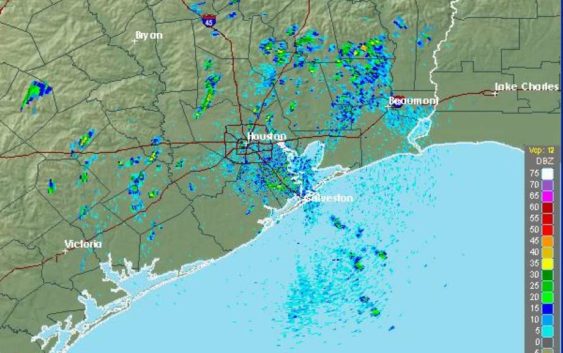
Photo: National Weather Service
Severe storms are expected to move through the Houston-area on Saturday. >> Click through the following gallery to see Houston’s largest one-day rain totals for the past few years.
Severe storms are expected to move through the Houston-area on Saturday. >> Click through the following gallery to see Houston’s largest one-day rain totals for the past few years.
Photo: National Weather Service
Strong to severe storms are expected ahead of a cold front early this morning and through the afternoon hours. National Weather Service predicts that isolated tornadoes, damaging winds, large hail and frequent lightning will be possible.
Plan ahead for possible heavy rain that may lead to street flooding. The worst of the severe weather may be north of I-10, according to NWS.
If you’re attending the Houston Art Car Parade at 2 p.m., please check back here for minute-by-minute forecast details.
This is a developing story.
NEWS WHEN YOU NEED IT: Text CHRON to 77453 to receive breaking news alerts by text message | Sign up for breaking news alerts delivered to your email here.