- Severe weather leads to fallen trees, car crashes and flooding around the Triangle
- New video shows vehicles being swept away in historic, deadly flash floods in SA on June 12
- $40 million to go to underserved SC counties for Hurricane Helene recovery. Here's what you need to know.
- Family honors Air Force veteran Derwin Anderson Jr. after he died in June flash floods
- City of Wilmington addresses flooding on New Centre Drive
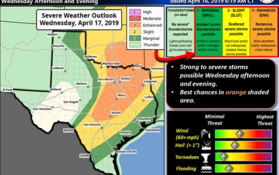
NWS: Tornadoes, 'very large' hail, 60+ mph winds possible Wednesday
-
Tornadoes, “very large” hail and severe wind is possible Wednesday in South Central Texas, according to the National Weather Service.
Tornadoes, “very large” hail and severe wind is possible Wednesday in South Central Texas, according to the National Weather Service.
Photo: National Weather Service
Tornadoes, “very large” hail and severe wind is possible Wednesday in South Central Texas, according to the National Weather Service.
Tornadoes, “very large” hail and severe wind is possible Wednesday in South Central Texas, according to the National Weather Service.
Photo: National Weather Service
Tornadoes, “very large” hail and severe wind is possible Wednesday in South Central Texas, according to the National Weather Service.
The storms are expected to begin around mid-afternoon Wednesday and last through midnight Thursday. According to the NWS, the first storms will form over the Edwards Plateau and Hill Country, then merge and approach the Interstate 35 corridor at about 6 p.m. They will then shift east to the Coastal Plains.
FIND OUT FIRST: Get San Antonio breaking news directly to your inbox
San Antonio and Bexar County are at slight risk for severe weather, meaning scattered severe storms are possible, but they will likely be short-lived or not widespread. Intense, isolated storms, however, are possible.
If the San Antonio-area does receive hail, it could range in size from very small to golf ball-sized. The greatest threat to the area, according to the weather service, is straight line winds reaching up to or higher than 60 mph Wednesday evening.
RELATED: NWS: Severe storms may bring quarter-size hail to San Antonio
The most severe weather is anticipated north of Bexar County, The Hill Country and Edwards Plateau will be at the greatest risk for “very large hail,” defined as golf ball-sized or larger. According to the NWS, one or two tornadoes are possible around sunset, when the storm has moved over the I-35 corridor.
Rainfall is expected to stay between 1/4 of an inch to 1 inch across the region, though isolated storms could produce up to 3 inches in certain areas, creating the potential for flooding.
Text “NEWS” to 77453 for breaking news alerts from mySA.com
Caleb Downs covers crime in San Antonio and Bexar County. Read him on our breaking news site, mySA.com, and on our subscriber site, ExpressNews.com |
cdowns@mysa.com | @calebjdowns