- WATCH: Video Shows Confirmed Tornado touches down in Columbus County
- Residents begin clean up after storms, apparent tornado roll through NC Tuesday
- Flooding lingers in Liberty County neighborhoods near Trinity River with more rainfall expected
- North Carolina behind on hurricane preparedness, study shows
- North Carolina way behind on hurricane preparedness, study shows
Multiple tornado warnings issued as severe storms move into Charlotte area
CHARLOTTE, N.C. — Multiple tornado warnings have been issued for parts of the Charlotte area in South Carolina as a large storm system moved across the Carolinas Friday.
A tornado warning is in effect for Chester and Union counties in South Carolina until 2:45 p.m. A tornado warning is in effect until 3:15 p.m. for western York County. The remainder of the Charlotte area is under a tornado watch until 5 p.m.
First Warn chief meteorologist Brad Panovich said the strongest threat remains damaging winds but he can’t rule out tornadoes during Friday’s event, particularly in areas east of I-77.
Panovich said the worst of the weather started moving in around 1:30 and will last through about 6 o’clock Friday.
“The worst is moving in right now,” Panovich said. “Some storms in Union County I’ve noticed some rotation every once in a while. Same thing in western parts of Gaston and Cleveland counties. Not tight enough to be tornado warnings but ones I’m keeping an eye on.”
By 1 p.m., heavy rain was spotted in Burke County along I-40.
Panovich expects the worst weather — heavy rains, damaging winds and possible tornadoes — will last for at least a couple of hours.
“Damaging wind potential is very high and the flash flood threat is increasing in the mountains,” Panovich said.
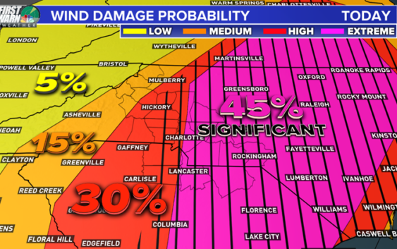
The National Weather Service put areas east of Charlotte in the extreme category for probable wind damage, something that’s rarely seen in the Carolinas. And as Charlotteans know, trees in the Myers Park area fall during any storm, so gusty winds above 35 mph could be problematic and lead to damage and widespread power outages.
RELATED: TIMELINE | Potential severe weather in Charlotte Friday
“When you get winds over 55 mph that can cause a lot of major problems,” First Warn forecaster Larry Sprinkle said. “Just because there’s no watch right now doesn’t mean we can’t see isolated spin-ups, those smaller tornadoes, this afternoon.”

The probability of wind damage in the Chalrotte area is significant Friday, especially in areas east of the city.
WCNC
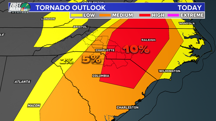
The Carolinas will be at risk for tornadoes during Friday’s storms, including an elevated threat east of Charlotte.
WCNC
Sprinkle said some areas south and east of Charlotte could see up to 2 inches of rain, while nearly every area will receive at least a half-inch from the storms. The storms will move out of the Charlotte area Friday night.
Saturday will be cooler in the 60s while Easter Sunday will be a beautiful sunny day with afternoon highs in the mid-70s.
POPULAR ON WCNC.COM
CMPD Chief Putney: Only one body camera worked during deadly shooting
Cabarrus County Schools among other districts closed May 1
North Carolina ‘born alive’ abortion bill wins final passage
Girl suspended for kneeing boy in groin who was in girls’ school bathroom
‘Dangerous’ woman ‘infatuated with Columbine shooting’ prompts manhunt