- Seven months after Hurricane Helene, Chimney Rock rebuilds with resilience
- Wildfire in New Jersey Pine Barrens expected to grow before it’s contained, officials say
- Storm damage forces recovery efforts in Lancaster, Chester counties
- Evacuation orders lifted as fast-moving New Jersey wildfire burns
- Heartbreak for NC resident as wildfire reduces lifetime home to ashes
Panovich: High threat for severe weather in Charlotte; 'off the charts' wind energy
CHARLOTTE, N.C. — The Easter weekend will get off to a stormy start in the Charlotte area thanks to a large storm system that will bring the potential for severe weather Friday afternoon.
First Warn chief meteorologist Brad Panovich said the strongest threat remains damaging winds but he can’t rule out tornadoes during Friday’s event, particularly in areas east of I-77.
“It’s east of I-77 that really concerns me,” Panovich said. “The tornado threat has crept up into the medium range. These are not going to be isolated in little cells, they’re going to be embedded. They’re going to be fast-moving and they’re going to be hard to warn for.”
RELATED: TIMELINE | Potential severe weather in Charlotte Friday
Two tornado warnings were issued just east of Greensboro around 9:30 Friday morning. Panovich expects a severe thunderstorm watch to be issued for the entire Charlotte area by lunchtime as the storms move in.
“When you get winds over 55 mph that can cause a lot of major problems,” First Warn forecaster Larry Sprinkle said. “Just because there’s no watch right now doesn’t mean we can’t see isolated spin-ups, those smaller tornadoes, this afternoon.”
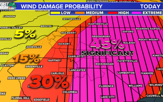
Panovich said the threat for damaging winds in the Charlotte area, especially east of I-77, is in the extreme range and should be everyone’s top priority. As for tornadoes, the threat is about 10 percent, which Panovich said is extremely high.
“That means there’s a 10 percent chance of seeing a tornado within 25 miles of any point on the map in the red area,” he said.

The probability of wind damage in the Chalrotte area is significant Friday, especially in areas east of the city.
WCNC
Sprinkle said the mountains and foothills will see the first rain with some scattered showers well before noon. Those storms will push east and reach Charlotte between noon and 2 p.m.
Panovich believes the time between 2 p.m. – 3 p.m. will be when Charlotte experiences the worst weather of the day.
“That two to three time frame seems to be the perfect time, or worst time, for the Charlotte area,” Panovich said. “The returns look a little better than yesterday, though.”
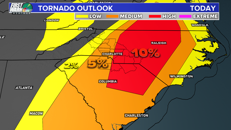
The Carolinas will be at risk for tornadoes during Friday’s storms, including an elevated threat east of Charlotte.
WCNC
Sprinkle said some areas south and east of Charlotte could see up to 2 inches of rain, while nearly every area will receive at least a half-inch from the storms. The storms will move out of the Charlotte area Friday night.
Saturday will be cooler in the 60s while Easter Sunday will be a beautiful sunny day with afternoon highs in the mid-70s.
POPULAR ON WCNC.COM
CMPD Chief Putney: Only one body camera worked during deadly shooting
Cabarrus County Schools among other districts closed May 1
North Carolina ‘born alive’ abortion bill wins final passage
Girl suspended for kneeing boy in groin who was in girls’ school bathroom
‘Dangerous’ woman ‘infatuated with Columbine shooting’ prompts manhunt