- Mosquito activity on the rise due to rainfall, flooding across Texas
- Volunteers help Conroe community clean up in wake of flooding in Montgomery County
- Why leaders are urging NC residents to start hurricane prep now
- Storms could produce hail, damaging winds south of Charlotte
- Large hail and strong winds cause damage in San Marcos and the Hill Country
Tornado warning in effect for Alamance, Orange and Person counties Friday morning
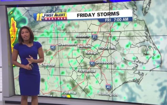
Chance of severe weather in Carolinas Friday
Watch the ABC11 weather forecast for information on possible severe weather moving through the Carolinas Friday, April 19, 2019.
Watch the ABC11 weather forecast for information on possible severe weather moving through the Carolinas Friday, April 19, 2019.
Raleigh
Severe storms could bring hail, strong winds and tornadoes to the Triangle Friday afternoon and evening, according to the National Weather Service.
Chapel Hill-Carrboro City Schools will close two hours early Friday because of the predicted storms, the district said on Twitter.
The announcement came after weather risks were upgraded to show the likelihood of widespread severe storms, the first alert of its kind for central North Carolina since 2016, the weather service says.
The line of storms moving eastward is expected to linger in the Triangle until 10 p.m. according to the National Weather Service. The eastern part of the state could see impacts until midnight, according to forecasters.
High winds are predicted starting at 11 a.m. for “areas along and east of U.S. 1,” according to the Raleigh office of the NWS. Forecasters predict there could be power outages and some damage to trees and buildings.
Wind gusts could reach 38 mph in the Raleigh area, and it could rain up to 1 inch during the day, with more showers predicted overnight, according to the forecast.
The rain is expected to clear by Saturday, when conditions will be “mostly sunny” with a high temperature of 64 degrees, the forecast says.
This story will be updated throughout the day.