- Rock Hill storm damage costs are 'somewhere around $5 million.' That number doesn't include damage to personal property
- Rock Hill storm damage costs are 'somewhere around $5 million.' That number doesn't include damage to personal property
- ‘Somewhere around $5 million’ | Rock Hill officials see major storm damage costs
- The deadliest tornadoes to ever hit Austin
- Whiteville resident recalls events from Tuesday nights tornado
Two inches of rain, damaging winds expected in Charlotte region Friday afternoon
Know your thunderstorm types
Ever heard of the term ‘supercell’ but didn’t know what it was? Learn about these powerful storms responsible for most tornadoes in the United States and other thunderstorms in this video from NWS.
Ever heard of the term ‘supercell’ but didn’t know what it was? Learn about these powerful storms responsible for most tornadoes in the United States and other thunderstorms in this video from NWS.
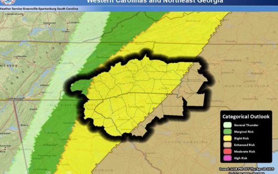
The Charlotte region of North Carolina will see severe thunderstorms, damaging wind gusts and possibly tornadoes on Friday afternoon, according to the National Weather Service.
Up to 2 inches of rain could fall in the afternoon and evening, forecasters say.
The “greatest widespread threat” for the foothills and Piedmont will be after 11 a.m. and could include wind gusts in excess of 58 mph “with a secondary threat for both tornadoes and severe hail,” NWS forecasters say.
Tornado and large hail warnings were issued Friday morning as the storm passed through northern Georgia, 150 miles west of Charlotte.
The thunderstorms were expected to reach the mountains in southwest North Carolina near daybreak and should “strengthen over the foothills through the morning hours, then intensify approaching the I-77 corridor Friday afternoon,” NWS said in a forecaster discussion.
Most of the unsettled weather is expected in the Charlotte region between 1 p.m. and 4 p.m., forecasters say.
“Localized excessive rainfall may cause flash flooding of small streams and urban areas,” NWS forecasters say.
The unsettled weather is associated with a “dynamic” cold front moving through the region, the National Weather Service says.
“There is a good chance that some of these storms could become severe as the front moves through the area,” the National Weather Service says. “Cooler temperatures and lingering showers are expected behind the front.”