- WATCH: Video Shows Confirmed Tornado touches down in Columbus County
- Residents begin clean up after storms, apparent tornado roll through NC Tuesday
- Flooding lingers in Liberty County neighborhoods near Trinity River with more rainfall expected
- North Carolina behind on hurricane preparedness, study shows
- North Carolina way behind on hurricane preparedness, study shows
Central Texas timeline shows when severe thunderstorms, flash flooding could hit
AUSTIN, Texas — A slow-moving area of low pressure is bringing rain and allowing for a chance of severe thunderstorms and flash flooding through the day on Wednesday in Central Texas.

kvue
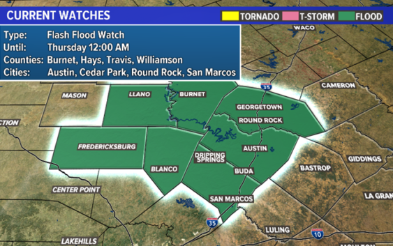
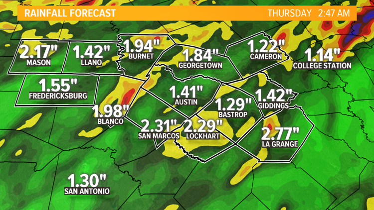
A Flash Flood Watch is in effect for Blanco, Burnet, Gillespie, Hays, Llano, Travis and Williamson counties from Wednesday morning through Wednesday evening. Rainfall amounts of one to three inches will be possible through Wednesday night, with isolated amounts of 4 to 6 inches possible.
kvue
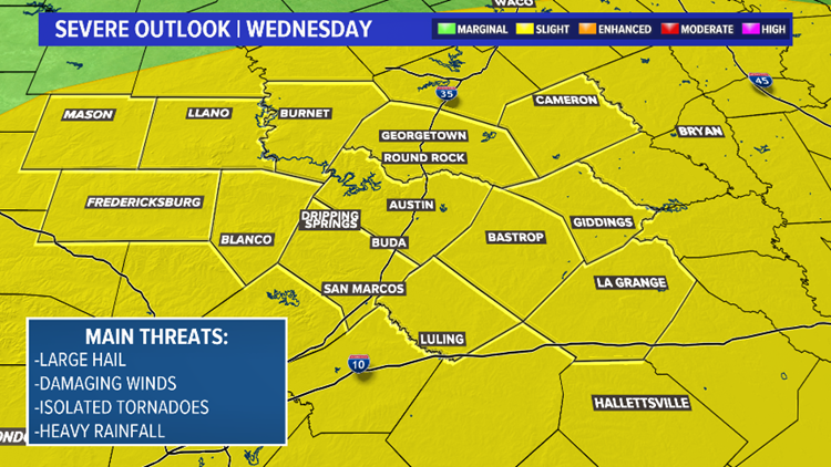
Along with a flash flood threat, severe storms will be possible on Wednesday. The Storm Prediction Center has outlined all of our area under a “Slight Risk,” which is a two out of five on the severe-threat scale. Large hail, damaging winds and isolated tornadoes will be possible.
kvue
Here’s the latest severe weather timeline for Central Texas:
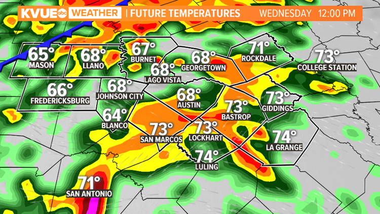
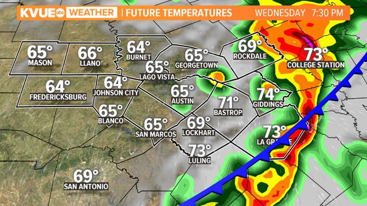
Scattered showers and storms continue for the rest of Wednesday morning. Storms will become more widespread and intense as we move toward lunch time.
KVUE
We’re expecting the most intense and most widespread storms around the Austin metro in the late afternoon and evening.

KVUE
For communities east of Interstate 35, dinnertime will be the best chances for heavy rain and intense storms.
KVUE
The storms and wet weather will be out of the area by late tonight. The skies will begin to clear shortly after.
By Thursday morning, we should be waking up to some sunshine.
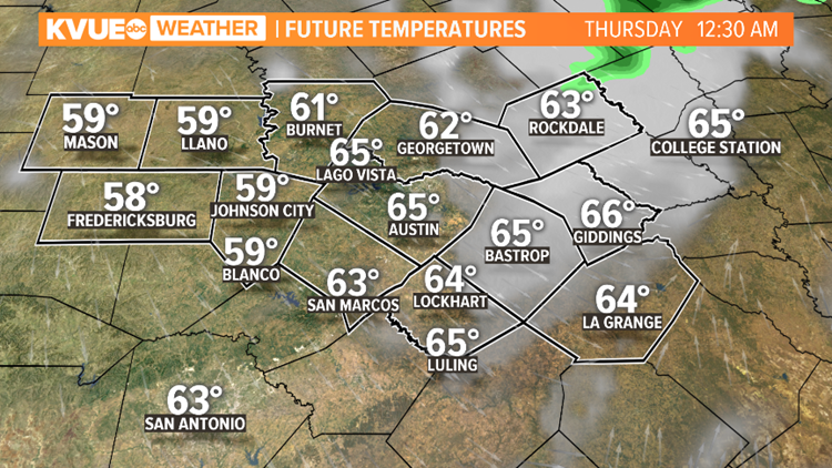
KVUE
As mentioned above, storms that do move into Central Texas have the potential for damaging winds above 60 mph and hail larger than the size of a quarter. The tornado risk at this point remains low.
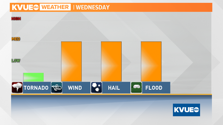
KVUE
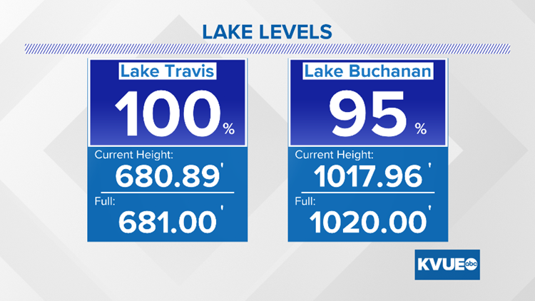
One other thing we’re going to watch closely this week is lake levels.
Lake Travis is at 100% and Lake Buchanan is at operational full. Unlike Travis, Buchanan does not have a flood pool, so when it’s at 100%, it’s full. The Lower Colorado River Authority (LCRA) has an agreement with FEMA to keep Lake Buchanan at or below 1,018 feet mean sea level during the wettest parts of the year.
RELATED: Explainer: How do the Highland Lakes and dams work?
The bottom line is that if heavy rainfall falls upstream of Lake Buchanan along the Colorado River or over the Highland Lakes, as some models are suggesting, there would be a possibility of dam operations later this week.
kvue
Stay tuned to KVUE for updates on this developing weather situation. Download the KVUE News app for updates and follow KVUE on YouTube, Facebook, Twitter and Instagram.
PEOPLE ARE ALSO READING:
Austin elementary teacher was under investigation when he died, police say
Convicted ringleader in James Byrd Jr. slaying to be executed Wednesday