- Southport hosts annual Hurricane Expo ahead of the 2024 season
- How to protect your car before a hailstorm
- ‘We lost everything’: East Texas residents confront their future after flooding
- Here's how to get your flooding debris picked up by the City of Houston
- Mosquito activity on the rise due to rainfall, flooding across Texas
Possible severe weather in parts of Central Texas

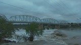
AUSTIN, Texas (FOX 7 Austin) – Parts of Central Texas could see another round of severe weather today for the second time in a week.
You can get the latest forecast here or if you’d like to follow the storms you can download or WAPP here.
Several inches of rain is expected to fall but the storm isn’t expected to be as severe as the most recent storm that came through.
Most of the severe weather is predicted to stay west with the Austin area getting hit this afternoon and the storms moving east by tonight.
The rain event today is less than ideal for cities like Franklin that’s still recovering from tornadoes.
There is a slight risk for flooding, lightning, strong winds, hail and the tornado threat is more likely to be west and south of San Antonio.
Officials are also keeping an eye on lake levels. Lake Travis is 100% full but officials say for right now there are no plans to open any of the flood gates.
Weather in Dallas is also causing issues including travel delays. Those delays are affecting flights out of Austin. You can get the latest on the your flight out of ABIA here.
____
READ MORE:
Austin Wildlife Rescue takes in 200 additional animals since recent storms
Austin, Travis County to be under Flash Flood Watch all Wednesday
Austin doorbell camera captures falling tree during storms
Storms cause some damage & power outages
Homes, businesses in Taylor prep for storm following recent flooding
Severe weather possible in parts of Central Texas