- Raleigh rethinks how to grow as flooding, heat and traffic worsen
- New legislative panels will investigate ‘facts and circumstances’ of deadly Central Texas floods
- Heavy rain floods downtown Whiteville forcing local businesses to deal with damage again
- New legislative panels will investigate “facts and circumstances” of deadly Central Texas floods
- Springfield Middle School fully reopens next week, a year after devastating EF3 tornado
Thunderstorms expected in southeast Texas
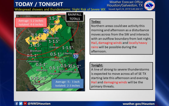
HOUSTON (FOX 26) – A line of strong to severe thunderstorms is expected to move across southeast Texas Thursday night, bringing with it the threat of hail and damaging winds, the National Weather Service says.
Strong to Severe storms will be possible across #SETX today and tonight. Please keep up with the forecast and take necessary precautions. Stay tuned! #Hail #StrongWinds #HeavyRains #houwx #bcswx #glswx #txwx pic.twitter.com/c61AYZud1h
— NWS Houston (@NWSHouston) April 24, 2019
Beginning this afternoon in the Houston area, scattered showers and storms are expected with an otherwise cloudy and breezy day. Tonight and very early Thursday a line of strong to severe storms will move through. Gusty winds and heavy rain are possible.
Storms should move out early tomorrow morning leaving behind much nicer weather through the weekend.
With integrated GPS, the FOX 26 Weather App “Follow Me” option will track you anywhere you go and you can enable weather alerts in your county. Download the app for free ==> bit.ly/2QCOKMm