- $40 million to go to underserved SC counties for Hurricane Helene recovery. Here's what you need to know.
- Family honors Air Force veteran Derwin Anderson Jr. after he died in June flash floods
- City of Wilmington addresses flooding on New Centre Drive
- Harnett County fire: Two homes damaged
- Medical examiner identifies 13th victim from massive flash flood in San Antonio
Thunderstorms expected in southeast Texas
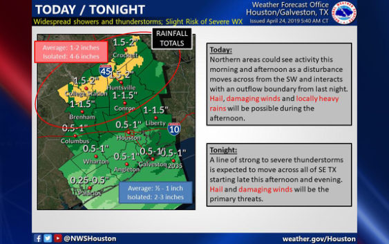
HOUSTON (FOX 26) – A line of strong to severe thunderstorms is expected to move across southeast Texas Thursday night, bringing with it the threat of hail and damaging winds, the National Weather Service says.
Strong to Severe storms will be possible across #SETX today and tonight. Please keep up with the forecast and take necessary precautions. Stay tuned! #Hail #StrongWinds #HeavyRains #houwx #bcswx #glswx #txwx pic.twitter.com/c61AYZud1h
— NWS Houston (@NWSHouston) April 24, 2019
Beginning this afternoon in the Houston area, scattered showers and storms are expected with an otherwise cloudy and breezy day. Tonight and very early Thursday a line of strong to severe storms will move through. Gusty winds and heavy rain are possible.
Storms should move out early tomorrow morning leaving behind much nicer weather through the weekend.
With integrated GPS, the FOX 26 Weather App “Follow Me” option will track you anywhere you go and you can enable weather alerts in your county. Download the app for free ==> bit.ly/2QCOKMm