- Whiteville resident recalls events from Tuesday nights tornado
- Tornado damage reported in southern NC after Tuesday's severe storms
- If your home floods, here are steps you can take to address mold
- WATCH: Video Shows Confirmed Tornado touches down in Columbus County
- Residents begin clean up after storms, apparent tornado roll through NC Tuesday
Houston weather: Tornado Warning issued for parts of Brazoria, Fort Bend counties
HOUSTON — A tornado warning has been issued for parts of Brazoria and Fort Bend counties until 2:15 a.m.
A severe thunderstorm watch is in effect until 3 a.m. Saturday for Brazoria, Colorado, Fort Bend, Harris, Matagorda and Wharton counties.
A flash flood watch remains in effect through Saturday afternoon. Many areas have already seen 2 to 4 inches of rain and an additional 1 to 2 inches of rain is expected. This could cause flash flooding especially in urban areas, low lying rural areas, poor drainage areas and rapid rises in area bayous.
This wet weather pattern will stay with us through midday Saturday.
And a Katy man tweeted video of a funnel cloud in Eagle Lake on Friday.
KHOU Reporter Brett Buffington spotted a dissipating funnel cloud in Wharton County.
At 12:25 p.m., a confirmed tornado touchdown occurred south of the Columbus airport near County Road 101 and 71, reports the National Weather Service.
Powerful winds tipped over a basketball goal in Spring near 2920 and Kuykendahl. There’s also water up to the curbs in that area.
KHOU viewer Eric Allen shot video of drivers trying to plow through high water in off 1960 in north Houston.
KHOU Reporter Jessica Borg reports flooded roads in the Tomball area.
The storms also knocked out power to at least 30,000 CenterPoint customers. By 6 p.m. the number was down to 23,000.
Several school districts issued shelter-in-place advisories, but all were lifted after the storms pushed through.
WEATHER RADAR: Track rain & storms across Texas
VIEW CURRENT ALERTS: Tap here for watches & warnings active now
GET ALERTS ON THE GO: Download the KHOU 11 app and follow us on Facebook and Twitter.
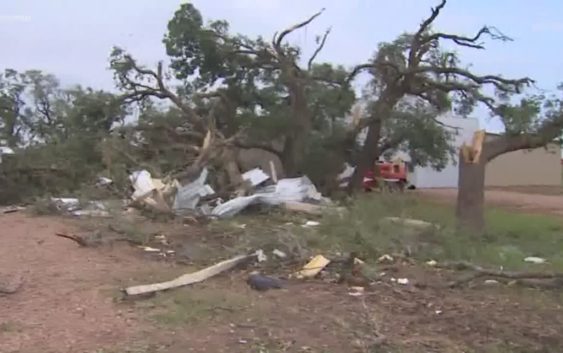
Possible tornado damage has been reported near La Grange in Fayette County.
The primary hazard for these storms are damaging winds, large hail and an isolated tornado. Heavy rain is also likely in areas.
Most 24-hour rain totals should be between 1 to 3 inches with isolated amounts up to 4. If that happens in a quick period of time there could be a few high water spots by late tonight or early tomorrow morning. View the complete weather timeline at the bottom of this article.
KHOU 11 Meteorologist Chita Craft says our chance for rain and thunderstorms ramps up late Friday and again early Saturday morning thanks to a weak front pushing through Texas.
Chita says most areas will see up an inch of rain, but isolated downpours could get up to four inches.
If you’re out late, watch out for street ponding.
Here are the details…
WEATHER TIMELINE:
FRIDAY PM – Rain lets up for the evening hours before moving back in for the overnight hours.
SATURDAY AM – 50 percent rain chance in the early-morning hours until about lunchtime. Low-70s. Thunderstorms possible. 24-hour rainfall totals could be up to four inches in some areas, which means some street flooding is not out of the question Friday into Saturday.
SATURDAY PM – Rain chance drops after the early afternoon, partly cloudy. Low to mid-80s.
SUNDAY – Very slight rain chance in the morning, partly cloudy. High temps near 90 degrees. A little sunshine possible.
NEXT WEEK – Slight rain chance Monday before more widespread showers and storsm return Tuesday, Wednesday and Thursday.
ALSO POPULAR ON KHOU.COM