- Mosquito activity on the rise due to rainfall, flooding across Texas
- Volunteers help Conroe community clean up in wake of flooding in Montgomery County
- Why leaders are urging NC residents to start hurricane prep now
- Storms could produce hail, damaging winds south of Charlotte
- Large hail and strong winds cause damage in San Marcos and the Hill Country
Flash flood warning for some area counties
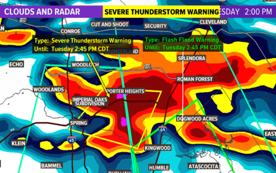
HOUSTON — A flash flood warning is in effect for Harris and Montgomery counties until 5:30 p.m. Tuesday.
There were reports of a possible tornado in Atascocita. KHOU 11 Chief Meteorologist David Paul doesn’t believe it was a tornado and there are no reports of damage in that area.
New Caney ISD officials said buses are not transporting students home as of 4 p.m. Tuesday. They said parents who are already at school to pick up their students can take them home. Students who drive themselves to school will not be released until further notice, according to the district.
Some areas have already seen as many as 5 inches of rain and there’s street flooding reported in Kingwood. Kingwood Drive is reportedly impassable near Highway 59.
There’s also street flooding in Spring. Pedro sent us video of high water near Aldine Westfield.
Jake Smookier shared video of pounding rain in Spring. He said the strong thunderstorm knocked out power in his neighborhood.
As of 4 p.m. Tuesday, Hobby Airport is experiencing delays averaging 1 hour and 11 minutes, and flights will not be allowed to depart until at least 4:30 p.m.
KHOU 11 Meteorologist Erika Lopez says another 2 to 4 inches of rain is possible this afternoon. Gusts up to 60 mph are also possible, along with quarter-size hail.
As of 2:09 p.m., CenterPoint said 10,000 customers are without power.
A strong jet stream overhead combined with a stalled surface frontal boundary plus heavy tropical moisture are the ingredients that can cause flooding in Houston and southeast Texas.
WEATHER RADAR: Track rain & storms across Texas
VIEW CURRENT ALERTS: Tap here for watches & warnings active now
GET ALERTS ON THE GO: Download the KHOU 11 app and follow us on Facebook and Twitter.
More flooding later this week?
As rounds of rain come through and fall on already saturated grounds, more street flooding is likely – especially Friday and Saturday. We’ll just have to watch and wait to see which area watersheds get the most rain and which creeks and bayous threaten to flood. The current forecast calls for rainfall totals of 3 to 4 inches along the coast, 4 to 5 inches in Houston and 5 inches in College Station and Huntsville.
Houston’s Public Works Dept. has already said it will lower the water levels in Lake Houston to prepare for the possibility of heavy rain.
Here’s what to expect this week…
WEATHER TIMELINE:
WEDNESDAY – 30% chance of scattered storms and rain in Houston area, high of 84. Look for mostly cloudy skies and temperatures in the mid 80s both days. Isolated storms can’t be ruled out but it should not be a widespread, all day event.
THURSDAY – 70% chance of storms and rain in Houston area, high of 84. Severe weather possible. High water spots possible due to saturated ground conditions.
FRIDAY – 70% chance of thunderstorms in Houston area, high of 84. High water spots possible due to saturated ground conditions.
SATURDAY- 70% chance for rain on Saturday, high of 82. Rainfall totals expected to be higher in areas north of Houston (College Station into Hunstville).
SUNDAY- 20% rain chance, high of 82 – calmer conditions for Mother’s Day.
ALSO POPULAR ON KHOU.COM: