- They couldn’t save their daughters’ lives in the July 4 floods. Now they’re dealing with the grief and the guilt.
- Austin could see heavy rains, possible flooding over the next few days
- Families of campers, counselors who died in Texas Hill County floods sue Camp Mystic
- Small plane bound for Jamaica with hurricane relief supplies crashes in Florida neighborhood
- Ask the Meteorologist: Did a tornado hit Johnston County Saturday night?
FORECAST: Flash Flood Watch & Severe threat Wednesday
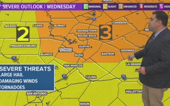
AUSTIN, Texas — Weather Outlook
Strong to severe thunderstorms will be possible Wednesday. Along with the threat of storms producing large hail, damaging winds and tornadoes, heavy downpours could also trigger flash flooding. Chances for scattered showers and storms continue Thursday, Friday & Saturday. Mainly dry Sunday for Mother’s Day.
RELATED: Storm Timeline: When to expect storms Wednesday
DETAILED FORECAST:
TUESDAY NIGHT:
Scattered showers and storms possible this evening. Southeast winds from 10 to 15 mph.
LOW: 70°
WEDNESDAY:
Flash Flood Watch. Cloudy skies with storms likely. 80% chance for rain. Some storms could be severe and produce heavy downpours. South winds at 10 to 15 mph.
HIGH: 82°
THURSDAY:
Mostly cloudy skies with scattered showers and storms. 70% chance for rain. Some storms could be strong and produce heavy downpours. East to northeast winds at 5 to 15 mph.
HIGH: 80°
RELATED: Allergy Report
Stay with KVUE on social media and download the KVUE News app so you can stay ahead of the storm. kvue.com/app