- Houston-area storm damage: Update on status of schools, power outages and resources for storm victims
- EF-1 tornadoes ripped through Cypress, Waller County areas with winds at more than 100 mph, NWS reports
- Houston-area storm damage updates: Clean up continues after NWS says two EF-1 tornadoes and powerful derecho ripped through SE Texas
- Low risk of damaging winds, hail from Saturday storms
- EF 1 tornadoes ripped through Cypress, Waller County areas at more than 100 mph, NWS reports
Severe storms could bring hail, damaging wind, ‘isolated tornado’ to Charlotte area
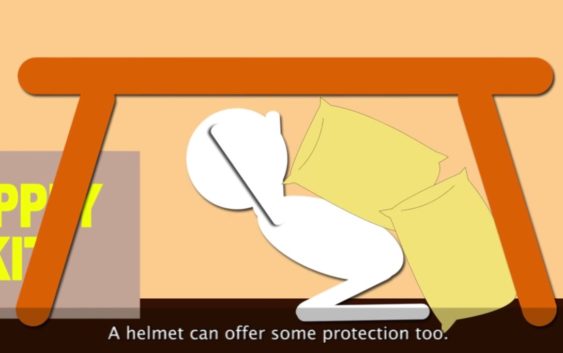
What to do during a tornado
If your area is under a tornado warning, then you may only have a few minutes to get to safety. Here are the actions you should take during a tornado.
If your area is under a tornado warning, then you may only have a few minutes to get to safety. Here are the actions you should take during a tornado.
Severe weather could deliver hail, damaging winds and “an isolated tornado” to the Charlotte region and the mountains this weekend, according to a hazardous weather update from the National Weather Service.
Torrential downpours could flood roads, NWS meteorologists also warned in the update at 6 a.m. Saturday.
“There is a chance for thunderstorms approaching severe limits this afternoon with the primary threat being strong wind gusts,” meteorologists from the NWS office in Greer, S.C., posted. “Isolated flash flooding is also possible from the heaviest thunderstorms.”
The hazardous weather statement also covers the Greenville-Spartanburg area of South Carolina besides SC counties closer to Charlotte, including York and Chester.
The threat of severe storms will continue into Sunday, meteorologists said. The best chance will come in the afternoon, “as vertical wind shear increases with the advance of an upper-level storm system,” according to the update.
“Damaging winds are again the main threat, but some hail is possible, and a brief, isolated tornado cannot be ruled out,” NWS forecasters said.
The chance of showers at Charlotte Douglas International Airport stands at 70 percent Saturday afternoon, and 80 percent late Saturday and all day Sunday, according to the latest NWS forecast just before Saturday
This story is developing. Check back for updates.