- EF-1 tornadoes ripped through Cypress, Waller County areas with winds at more than 100 mph, NWS reports
- Houston-area storm damage updates: Clean up continues after NWS says two EF-1 tornadoes and powerful derecho ripped through SE Texas
- Low risk of damaging winds, hail from Saturday storms
- EF 1 tornadoes ripped through Cypress, Waller County areas at more than 100 mph, NWS reports
- Caddo Mounds State Historic Site to celebrate new visitor center, traditional grass house after 2019 tornado
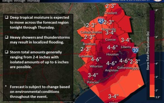
NWS: Tropical disturbance could dump 6 inches on Houston, flash flood watch now in effect
-
The National Weather Service predicts between 4 and 6 inches of rainfall for Houston as a tropical disturbance pushed through Southeast Texas on Tuesday, June 4, 2019.
The National Weather Service predicts between 4 and 6 inches of rainfall for Houston as a tropical disturbance pushed through Southeast Texas on Tuesday, June 4, 2019.
Photo: National Weather Service
The National Weather Service predicts between 4 and 6 inches of rainfall for Houston as a tropical disturbance pushed through Southeast Texas on Tuesday, June 4, 2019.
The National Weather Service predicts between 4 and 6 inches of rainfall for Houston as a tropical disturbance pushed through Southeast Texas on Tuesday, June 4, 2019.
Photo: National Weather Service
Much of the Houston area can expect between 4 and 6 inches of rain as a tropical disturbance makes its way toward Southeast Texas, according to the National Weather Service.
Rain is expected to start Tuesday night and last until Thursday. The expected rainfall prompted NWS meteorologists to issue a blanket flash flood watch for all of Southeast Texas until Thursday morning.
The disturbance is currently disorganized, but it’s expected to move toward the northeastern coast of Mexico later Tuesday. Meteorologists say there’s a 50 percent chance it develops into a cyclone before before moving inland.
The disturbance is expected to produce heavy rain in southeast Texas and Louisiana through Thursday, regardless of its development, the weather service said. A flash flood watch will remain in effect from 1 a.m. Wednesday to 7 a.m. Thursday.
STAY INFORMED: Text HOUSTON to 77453 to get breaking news alerts by text | Sign up to receive breaking news alerts delivered to your email here.
An Air Force Reserve reconnaissance aircraft will investigate the system later today, if necessary.
The forecast shows a 70 percent chance for rain in Houston on Tuesday night, an 80 percent chance on Wednesday and a 70 percent chance on Thursday.
Julian Gill is a digital reporter in Houston. Read him on our breaking news site, Chron.com, and on our subscriber site, houstonchronicle.com. | julian.gill@chron.com | NEWS WHEN YOU NEED IT: Text CHRON to 77453 to receive breaking news alerts by text message | Sign up for breaking news alerts delivered to your email here.